
- Brief description
-
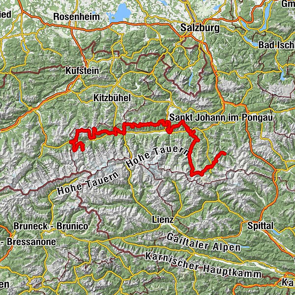
At eye level with Austria's highest mountains
- Difficulty
-
medium
- Rating
-
- Starting point
-
Tourist information Krimml
- Route
-
Krimml (1,067 m)Pfarrkirche Krimml0.0 kmOberhafen4.1 kmOberer Krimmler Wasserfall4.1 kmBerger Blick4.3 kmStaubige Reib (1,330 m)4.6 kmGasthof Schönangerl5.1 kmBergersteig (1,245 m)5.4 kmJagasprung (1,220 m)5.7 kmJung Kanzel (1,215 m)5.8 kmSendtner Kanzel (1,170 m)6.0 kmRegen Kanzel (1,150 m)6.1 kmUnterer Krimmler Wasserfall6.1 kmRieman Kanzel (1,110 m)6.4 kmHanke's Cafe- Restaurant Souvenir6.8 kmRupertiwinkel6.9 kmOberkrimml9.0 kmFilzsteinalm11.8 kmHochkrimml11.9 kmPlattenkogel (2,039 m)13.8 kmTrissl Alm19.0 kmAlpengasthof Finkau20.7 kmBärschlagalm (1,459 m)24.3 kmSeestüberl26.3 kmSterngucker31.5 kmKönigsleiten (1,602 m)32.1 kmHotel-Restaurant Ursprung32.3 kmSalzachhütte34.9 kmSalzachjoch (1,988 m)38.4 kmMarkkirchl (1,988 m)38.5 kmKröndlhorn (2,444 m)41.3 kmTrattenbach-Hochalm44.3 kmTrattenbach-Grundalm46.5 kmAlpengasthof Rechtegg52.6 kmTaubensteinkapelle56.1 kmSteineralm (1,559 m)57.5 kmGrasleitkopf (2,158 m)61.6 kmFrühmesser (2,233 m)62.3 kmBraunkogel63.4 kmGensbichlalm63.8 kmWolkenstein64.3 kmWolkenstein64.4 kmGensbichlscharte (2,021 m)64.5 kmGanzeralm65.1 kmKinderspielplatz65.2 kmRamba Zambar65.3 kmWildkogel Haus66.9 kmWildkogel Alm67.8 kmBergstation Smaragdbahn67.8 kmChristophorus Kapelle67.9 kmWildkogel (2,224 m)68.4 kmBergkristall74.9 kmSonnberg75.2 kmGeislhof75.3 kmMühlbach76.9 kmHollersbach im Pinzgau81.9 kmPfarrkirche St. Vitus82.0 kmReitlehen82.0 kmGrubing83.2 kmLämmerbichl83.6 kmPaßthurn88.5 kmHochmoor Stüberl90.0 kmSpielbichl93.3 kmMittersill95.5 kmMittersill Bahnhof95.5 kmThalbach99.5 kmRosswegscharte (2,060 m)104.2 kmSintersbachscharte (2,035 m)104.9 kmMurnauer Scharte (1,959 m)107.6 kmSommertörl (1,939 m)115.3 kmKlammscharte (1,993 m)125.7 kmRohrertörl (1,919 m)128.3 kmHochsonnbergalm129.4 kmKesselscharte (1,847 m)131.2 kmPinzgauer Hütte132.8 kmKettingtörl (1,780 m)133.9 kmEderhütte134.0 kmSchmittenhöhe (1,965 m)135.2 kmHochzeller-Alm135.6 kmSalersbachköpfl (1,934 m)136.5 kmSchmiedhofalm138.4 kmBlaickner140.9 kmJaga-Alm143.0 kmSchmitten144.6 kmKöhlergraben Hütte145.1 kmStadtpfarrkirche St. Hippolyt147.0 kmZell am See (750 m)147.0 kmInnenstadt147.0 kmAltstadt147.1 kmEsplanade147.9 kmEsplanade148.4 kmGrinzing149.2 kmEinöd149.4 kmSeewirt - Das Restaurant149.6 kmAbdeckerfeld149.8 kmPrielau150.6 kmGasthof Wieshof151.0 kmWiesenlehen151.3 kmThumersbach152.3 kmErlberg154.3 kmBruck an der Großglocknerstraße159.9 kmHl. Maria159.9 kmErlhofplatte164.3 kmMoosalmhöhe (1,843 m)170.1 kmHundstein (2,117 m)173.1 kmStatzerhaus173.1 kmPfarrachhöhe (1,922 m)176.1 kmRieser Aste179.7 kmTaxberg185.6 kmGschwandtnerberg186.0 kmPfarrkirche Taxenbach186.1 kmTaxwirt Pizzeria186.1 kmTaxenbach186.1 kmGasthof zur Post186.2 kmGrosser Wasserfall188.6 kmTropfsteingrotte (Station 4)188.7 kmKitzlochklamm188.9 kmRitzstollen188.9 kmHermitage188.9 kmGasthaus Maria Elend191.7 kmWahlfahrtskapelle Maria Elend191.7 kmGasthof Krämerwirt193.4 kmEmbach193.5 kmGasthof Oberwirt193.5 kmÖlbergkapelle194.4 kmGasthaus Maria Elend195.2 kmWahlfahrtskapelle Maria Elend195.3 kmKapelleralm198.4 kmKatzenkopf (2,061 m)201.7 kmGrubereck (2,168 m)204.0 kmRauris209.0 kmKapelle211.4 kmWörth213.3 kmGusto213.4 kmAndrelwirt213.6 kmEinödkapelle215.0 kmBucheben218.3 kmGrünangerl-Quelle220.9 kmLechnerhäusl222.6 kmAmmerersölleralm223.4 kmSöllerlalm223.9 kmBodenhaus224.7 kmAmmererhof231.7 kmKolm-Saigurn232.8 kmDurchgangalm235.7 kmFilzenalm (1,784 m)236.4 kmZitterauer Alpe244.5 kmZitterauer Tisch (2,463 m)246.5 kmTischkogel (2,409 m)246.9 kmZitterauer Scharte (2,163 m)247.7 kmAussichtsplattform Glocknerblick248.4 kmGipfelrestaurant Stubnerkogel248.4 kmBergstadl251.3 kmAhornhütte251.9 kmPyrkershöhe254.7 kmBad Gastein255.4 kmGasteiner Wasserfall255.5 kmWasserfall255.5 kmPreimskirche255.7 kmBadberg256.4 kmBlick nach Bad Hofgastein256.7 kmPoserhöhe260.0 kmOberharbachalm265.9 kmSchappachkapelle271.1 kmHüttschlag271.1 km
- Best season
-
JanFebMarAprMayJunJulAugSepOctNovDec
- Description
-
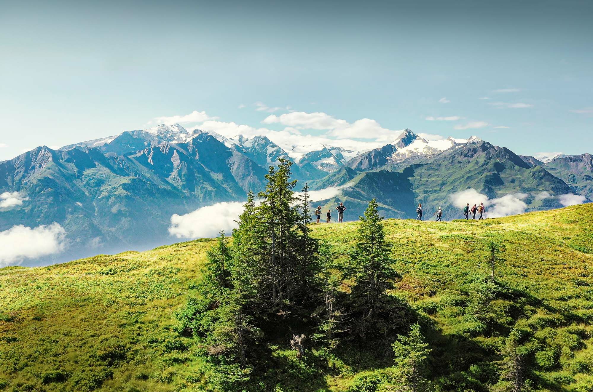
The Hohe Tauern Panorama Trail offers a long-distance hiking experience that's in a class of its own. In the course of seventeen daily stages, hikers cover a distance of 275 kilometres from the starting point at the foot of the Krimml Waterfalls over the Schmittenhöhe high above Zell am See to Hüttschlag. En route you will find stunning natural attractions, great exhibitions, picturesque national parks and attractive excursion destinations. The mountain railways and handy shuttle services at the stage destinations as well as optional luggage transfer offer maximum comfort.
Each day the long-distance hikers walk for three to seven hours - without rope and between 700 and 2,400 metres above sea level, affording panoramic views. Alternative routes are available if the main routes cannot be accessed during low season due to bad weather, such as snow at high altitudes.
TIP: Enjoy an unforgettable hiking experience on the High Tauern Panorama Trail! The official High Tauern Panorama Trail Information and Booking Center with the award-winning Trail Angels team is happy to assist you. Experience a combination of personal freedom and the yearning for the extraordinary, paired with service, comfort, and safety. Top offer: The Small Escape Package: 2 nights, 2 stages including luggage service, shuttle and return transfer, and much more, starting from €209.
- Directions
-
Detailed route descriptions can be found in the tour descriptions of stages 01-17.
- Highest point
- 2,445 m
- Endpoint
-
The hiking park in the centre of Hüttschlag
- Height profile
-

- Equipment
-
You need alpine hiking equipment for the Hohe Tauern Panorama Trail:
Day backpack, capacity: 25-30 litres, with waist belt and rain cover
Hiking boots - minimum category B
Weather-adapted and hard-wearing clothing in multiple layers. The Hohe Tauern Panorama Trail is mostly at altitudes between 1,300m and 2,450m - this should be taken into account when choosing your hiking equipment (especially your clothing).
Height-adjustable trekking poles
Sun and rain protection
Make sure take enough to eat and sufficiently large water bottles with you, as there are not refreshment stops and fountains on all stages (e.g. on stages 5 and 7).
First aid kit
Pocket knife
Mobile phone
Tour description or hiking map - Safety instructions
-
On the Hohe Tauern Panorama Trail you travel as an individual hiker (without the guidance of a mountain guide) on marked mountain paths, partly in high alpine mountain regions with altitudes of up to 2.450 m.
For the Hohe Tauern Panorama Trail you need alpine hiking experience, which includes not only the correct self-assessment of the technical and physical requirements for the points, but also experience in orientation in the terrain (including reading topographical maps) and in how to react in case of bad weather.
If desired, you will be well looked after and supported on the Hohe Tauern Panorama Trail by the Trail Angels information and booking platform. Nevertheless, you are on the trail as an independent hiker (unless you book a mountain hiking guide as an option). We would like to point out that you are on your own responsibility on the Hohe Tauern Panorama Trail.
- Tips
-
Uniform signposts are attached to the entire Hohe Tauern Panorama Trail for orientation. The signs are 20x20 cm and always point in the direction of Zell am See and from Zell am See eastwards in the direction of Hüttschlag. For stages 12, 15 and 16 we recommend shortening part of the route by public transport (saving 20.2 km) - details in the stage descriptions.
- Additional information
- Directions
-
Arrival by car:
Coming from the north - (Vignette required!) (D, NL, ...): Munich - Kufstein - St. Johann in Tirol - Kitzbühel - Pass Thurn - Hohe Tauern National Park holiday region
Coming from the west (CH): Inntal - Motorway (A12 = toll sticker required!) - Wörgl Ost exit - St. Johann in Tirol - Kitzbühel - Pass Thurn - Hohe Tauern National Park holiday region
Coming from the east: Vienna - Salzburg (A1 = toll sticker required!) - Lofer - St. Johann in Tirol - Kitzbühel - Pass Thurn - Hohe Tauern National Park Holiday Region
Coming from the south: Lienz - Matrei - Felbertauernstrasse (toll) - Hohe Tauern National Park Holiday Region
Arriving by plane - nearest airports: Salzburg, Innsbruck, Munich
- Public transportation
- Parking
-
Parking is available at the respective starting points of the trail trip. Most of the parking spaces are free and not monitored!
-

-
AuthorThe tour Hohe Tauern Panorama Trail | entire trail is used by outdooractive.com provided.