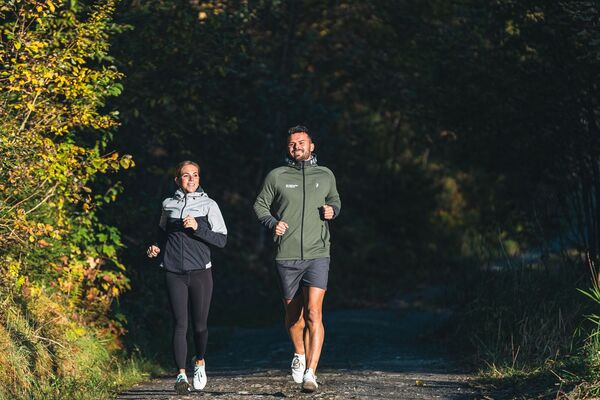

- Brief description
-
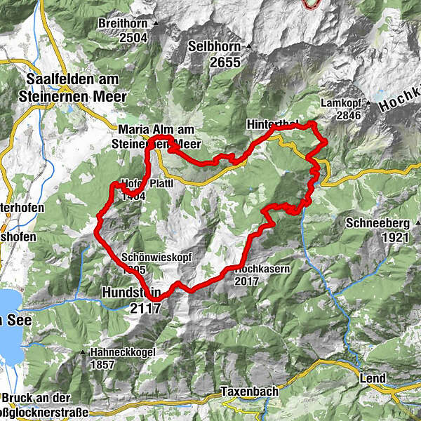
49,9 km / 3060 hm+ finest trails in the Hochkönig region - this is the Hochkönigman Marathon Trail
- Difficulty
-
difficult
- Rating
-
- Starting point
-
Maria Alm Natrunbahn car park
- Route
-
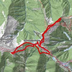
Maria Alm am Steinernen Meer0.0 kmSimmerllift0.2 kmNatrunbahn 10er Kabinenbahn2.7 kmNatrun (1,253 m)3.5 kmJufenalm4.8 kmWetterherrenkapelle4.9 kmBirnbach7.9 kmHinterthal9.3 kmKath. Pfarrkirche hl. Dreifaltigkeit9.4 kmPichl Alm13.4 kmDienten am Hochkönig17.8 kmGrünegg Alm20.0 kmMarbachhöhe (1,814 m)25.9 kmKlingspitz (1,988 m)27.4 kmHochkasern (2,017 m)28.1 kmHundstein (2,117 m)32.1 kmStatzerhaus32.2 kmQuelle33.2 kmOchsenkopf (1,995 m)33.2 kmSchönwieskopf (1,995 m)36.3 kmSchwalbenwand (2,011 m)37.9 kmHofer Plattl (1,404 m)41.1 kmHinterjetzbachalm42.6 kmArbesreitalm43.3 kmSchattberg45.3 kmSchloßberg46.3 kmMaria Alm am Steinernen Meer47.0 kmWallfahrtskirche Maria Alm47.3 km
- Best season
-
JanFebMarAprMayJunJulAugSepOctNovDec
- Description
-
The marathon distance is a very challenging distance and requires some training and preparation to master the 49.9km and 3060 hm+.
The route offers a lot of variety and breathtaking views and it takes you from Maria Alm to Dienten and back again on the opposite side. The highest point to climb is the Hundstein with 2117 hm+.
The current best time for this distance is an incredible 4:32:42 hrs and the time limit is 12 hrs. - Directions
-
After the start at the "Trailbase Hochkönigman" (Natrunbahn car park) at 807m, walk past the Natrun cable car and a few metres behind it turn left up an alpine path to the top station of the Natrun cable car. At the top, leave the mountain station on the right and walk straight through the forest rope park in the direction of Prinzensee. There are some great forest trails uphill before a short descent and a short flat section to the Jufenalm.From the Jufenalm, after a short climb in the direction of Brimbachkögerl, turn right downhill over Stöckl and follow the Hochkönig main road to Hinterthal.
Walk through Hinterthal and at the end of the village centre the trail leads you to the Mußbachalm and on to the Pichlalm at 1434m, which you then leave to the Filzensattel 1290m. At the Filzensattel, please be careful when crossing the road (federal highway), continue over the Pureggalm 1309m to Dienten.
From Dienten you continue over steep trails to the Lettelalm 1524m, the Grinnköpfl 1707m, the Marbachhöhe 1814m and the Klingspitz 1988m up to the Hochkaser 2017m, before descending a few metres and turning left into the forest road to the Statzerhaus.
Great views await you over the great Grasberg trails towards Schwalbenwand 2011m, before continuing over Brunnkopf 1958m via Oberstegalm to Hinterjetzbach- and Arbesreitalm and Schattberg to Maria Alm. Just pass under the road bridge and turn right to return to the "Trailsbase Hochkönigman" (Natrunbahn car park) at approx. 50km.
- Highest point
- 2,095 m
- Endpoint
-
Maria Alm Natrunbahn car park
- Height profile
-

- Equipment
-
Trail running shoes
Sticks
Headgear
Sun protection
Sunglasses
Rain protection
Drinks and a snack
Necessary medication
First aid kit
Hiking map - Safety instructions
-
Self-assessment Check your physical fitness before each tour and assess your strength correctly!
Planning and preparation Plan each intended tour in detail beforehand.Equipment On the mountain you need appropriate equipment and clothing, especially weather and cold protection are essential as the weather can often change unexpectedly.
Weather forecasts Take note of the current weather conditions at: www.zamg.at
Together Observe the 10 rules for the correct handling of grazing animals and do not leave any waste in nature!
Turn back in good time This is not a disgrace, but a sign of common sense. It becomes necessary when the weather changes, fog rolls in, and also when the path is too difficult or not in good condition.
Stay on the marked paths
Emergency numbers: Alpine emergency call: 140
International emergency call: 122 - Tips
-
Please note that you are walking on a ridge on the section between Dienten and Maria Alm (Marbachhöhe / Klingspitz / Hochkasern / Hundstein / Schwalbenwand)!
This section offers absolutely no protection during thunderstorms and should be avoided at all costs in this case. - Additional information
- Directions
-
Coming from Salzburg: Take the A10 motorway to the Bischofshofen exit, then take the B311 towards Bischofshofen. Follow the Hochkönig Bundesstraße/B164 to Maria Alm.
Coming from Innsbruck/ Kufstein: Take the Loferer Straße/B178 in the direction of St. Johann i.T., then follow the Hochkönig Bundesstraße/B164 via Saalfelden to Maria Alm.
A valid vignette is required to use the Austrian motorway and motorway network. It is also compulsory to carry a first-aid kit, warning triangle and high-visibility waistcoat. Further information can be found under Asfinag. - Public transportation
- Parking
-
Free parking at the beginning of the village and in the centre of Maria Alm


- Author
-
The tour HOCHKÖNIGMAN Marathon Trail is used by outdooractive.com provided.