© Zell am See-Kaprun Tourismus GmbH - Mr.Offenblende.at

- Brief description
-
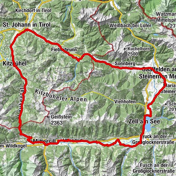
Cross-boarder pass tour
- Difficulty
-
difficult
- Rating
-
- Route
-
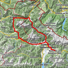
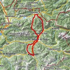
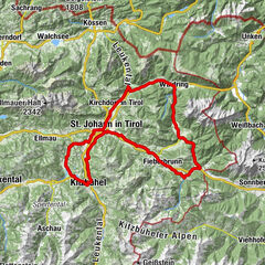
Zell am See (750 m)InnenstadtAltstadt0.0 kmHeldenhain0.8 kmSeespitz1.4 kmSüdtirolersiedlung2.1 kmSchüttdorf2.2 kmSchüttgut2.6 kmBrückenwirt4.9 kmKaprun7.5 kmEinödhof9.5 kmPiesendorf11.8 kmHummersdorf13.9 kmJesdorf17.3 kmNiedernsill18.2 kmSteindorf18.5 kmLengdorf20.0 kmUggl22.3 kmTobersbach23.1 kmGasthof Tischlerwirt24.0 kmUttendorf24.1 kmKirche zum hl. Rupert24.4 kmLitzldorf25.4 kmPirtendorf26.6 kmHörfarter27.4 kmStuhlfelden27.8 kmWilhelmsdorf28.8 kmFelberkirche31.4 kmFelben31.4 kmMittersill32.3 kmEvang. Annakirche32.4 kmRettenbach35.4 kmLämmerbichl36.7 kmHohe Brücke39.2 kmPaßthurn40.0 kmWaldwirt46.0 kmWallfahrtskirche Mariae Heimsuchung46.0 kmGasthof Alte Wacht48.4 kmDorfstub'n Jochberg50.7 kmAlpenland50.8 kmPfarrkirche Heiliger Wolfgang51.4 kmJochberg51.5 kmGrill House53.4 kmAurach bei Kitzbühel55.4 kmGrillstation Kebab 9255.9 kmAuwirt Hotel & Restaurant56.2 kmUnteraurach56.6 kmBusiness58.7 kmFranziskanerkirche60.2 kmKitzbühel60.5 kmStegerwiese63.0 kmWalswegen63.9 kmWeiberndorf69.0 kmFoidler69.2 kmFixlweber69.3 kmApfeldorf69.9 kmParzach70.6 kmSt. Johann in Tirol71.2 kmAntoniuskapelle71.4 kmSt. Johann in Tirol71.4 kmKlettenhäusl71.8 kmMaurerhäusl71.8 kmSchilden71.8 kmRoaner72.3 kmGrandern in Alpendorf72.3 kmBeim Mair72.3 kmEvangelikale Freikirche72.3 kmBrünntal-Häusl72.4 kmFiechtern72.4 kmZellern72.4 kmEichenhof73.0 kmGrieslederer74.2 kmGrieswirt74.3 kmGrub78.0 kmSchradl-bühel79.6 kmAm Berg80.5 kmPizzeria San Marco81.0 kmFieberbrunn81.8 kmJohanneskapelle81.9 kmPrama82.4 kmBrunnau82.5 kmWalchau83.3 kmDandlerau84.0 kmRecherkapelle89.2 kmPfarrkirche Maria Schnee89.4 kmHochfilzen89.5 kmRestaurant im Hotel Edelweiß89.5 kmHochfilzen90.2 kmPizzeria Restaurant Hochfilzner Hof90.2 kmPass Grießen (975m)91.9 kmGrießen93.7 kmBerg95.8 kmHütten97.4 kmLeogang101.3 kmRosental102.0 kmHirnreit102.6 kmFischerhütte103.0 kmUttenhofen104.5 kmDorfheim107.7 kmSaalfelden am Steinernen Meer (748 m)108.7 kmThor109.1 kmPfaffing110.6 kmSchmieding110.8 kmHof112.1 kmDeuting112.9 kmRuhgassing113.6 kmGerling114.6 kmGerlingerwirt114.7 kmHl. Gotthard114.8 kmOberhaus115.5 kmStiegerschlössl118.5 kmMaishofen118.5 kmWiesenlehen121.3 kmGasthof Wieshof121.4 kmPrielau122.0 kmAbdeckerfeld122.8 kmSeewirt - Das Restaurant123.0 kmEinöd123.4 kmGrinzing123.4 kmEsplanade124.1 kmInnenstadt124.5 kmAltstadt124.5 kmZell am See (750 m)124.6 km
- Best season
-
JanFebMarAprMayJunJulAugSepOctNovDec
- Directions
-
Starting from Zell am See, take the Brucker Bundesstraße to Schüttdorfand follow the well-signposted ‘Tauernradweg’ to Mittersill.Pass the town of Mittersill and stay on the ‘Kürsingerdamm’ roaduntil the turn-off into the Rettenbachstraße. The route leads thenuphill on the Passthurn Straße B161 and, after crossing the pass,continues to Jochberg, Aurach and Kitzbühel. Passing Oberndorf,continue on the B161 until the turn-off Speckbacherstraße. Carry ontowards Fieberbrunn, Hochfilzen, Leogang and Saalfelden. Returnto Zell am See via Gerling, Schloss Kammer and Maishofen.
track sign: R5
- Highest point
- 1,281 m
- Endpoint
-
Zell am See
- Height profile
-

- Public transportation
-
train station Zell am See
-

-
AuthorThe tour Kitzbühler Runde (R5) is used by outdooractive.com provided.
GPS Downloads
General info
Refreshment stop
Other tours in the regions