- Brief description
-
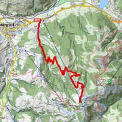
Challenging, scenically magnificent loop between Saalbach and Fieberbrunn.
- Difficulty
-
difficult
- Rating
-
- Starting point
-
Saalbach centre
- Route
-
Saalbach0.2 kmSpielberghaus (1,320 m)3.5 kmBurgeralm (1,260 m)4.7 kmEiserne Hand9.4 kmReiteralm20.8 kmWieseralm22.2 kmEdelweiss Alpenkino22.9 kmHinterglemm26.7 kmWieshoflift27.3 kmMitteregglift27.5 kmAchrain28.1 kmEibing28.7 kmSaalbach30.3 km
- Best season
-
JanFebMarAprMayJunJulAugSepOctNovDec
- Description
-
From Saalbach you start on the forest path along the Spielbergbach stream up to the Spielberghaus and then immediately reach Tyrolean soil. A long (approx. 5 km), quite comfortable descent lies ahead, at the end of which you can take a break at the Eiserne Hand inn. On the way you can see the facilities of the nearby magnesite factory in Hochfilzen. The route now climbs again along the Schwarzache into the Hörndlinger Graben. The steepest part of the tour begins shortly before the Scherm powder maker. You climb up countless narrow serpentines (the eponymous Hennerleiter) and reach the highest point of the tour at the Wetterkreuz after just under 600 hm. From here, depending on your mood, you can ride down to Hinterglemm on single trails (Wetterkreuz trail, Blue Line or Pro Line) or forest paths and continue along the Glemmtal cycle path to the starting point in Saalbach.
- Highest point
- 1,641 m
- Endpoint
-
Saalbach centre
- Height profile
-

- Tips
-
Download the track sheet.
- Directions
-
From Maishofen. approx. 14 kms along the L111 to the Schattberg X-press car park in Saalbach.
- Public transportation
- Parking
-
Car parking free of charge at the Schattberg X-press.
Parking is only free of charge when you purchase a lift ticket between 8.00 - 18.00 hours.
The parking ticket can only be validated at the bottom station of the Schattberg X-press lift.

- Author
-
The tour SH 72 Hennerleiter Tour is used by outdooractive.com provided.


General info
-
Saalbach Hinterglemm
434
-
Hochfilzen
141