Salzburger Almenweg - Stage 13: Loosbühelalm - Gernkogel/St. Johann


- Brief description
-
Panoramic alpine hike with a Glockner view
- Difficulty
-
medium
- Rating
-
- Starting point
-
Loosbühelalm (1,769 m), Großarl
- Route
-
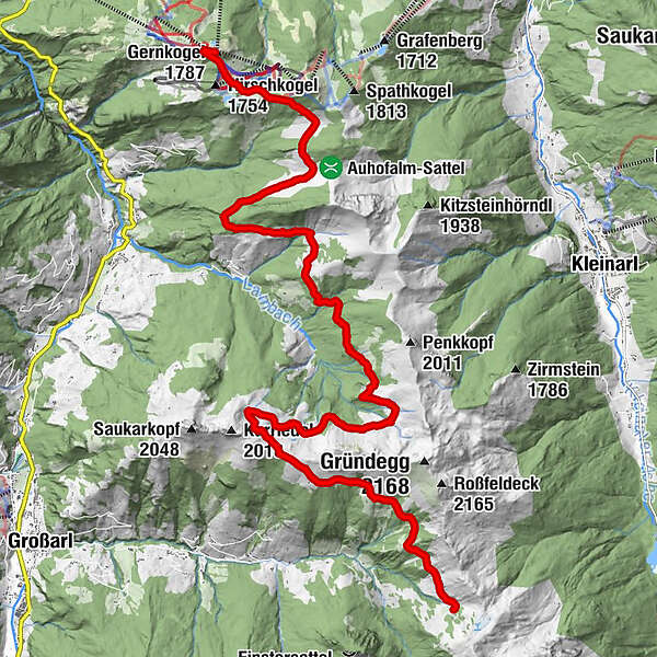
Loosbühelalm (Klausalm)0.0 kmWeißalm1.4 kmEllmaualm2.6 kmGroßwildalm9.2 kmKarsegg-Heimalm12.3 kmUnterwandalm13.1 kmMuggenfeldalm (Rothofalm)15.1 kmMaurachalm16.0 kmObergaßalmbahn19.1 kmGernkogel (1,787 m)19.2 km
- Best season
-
JanFebMarAprMayJunJulAugSepOctNovDec
- Description
-
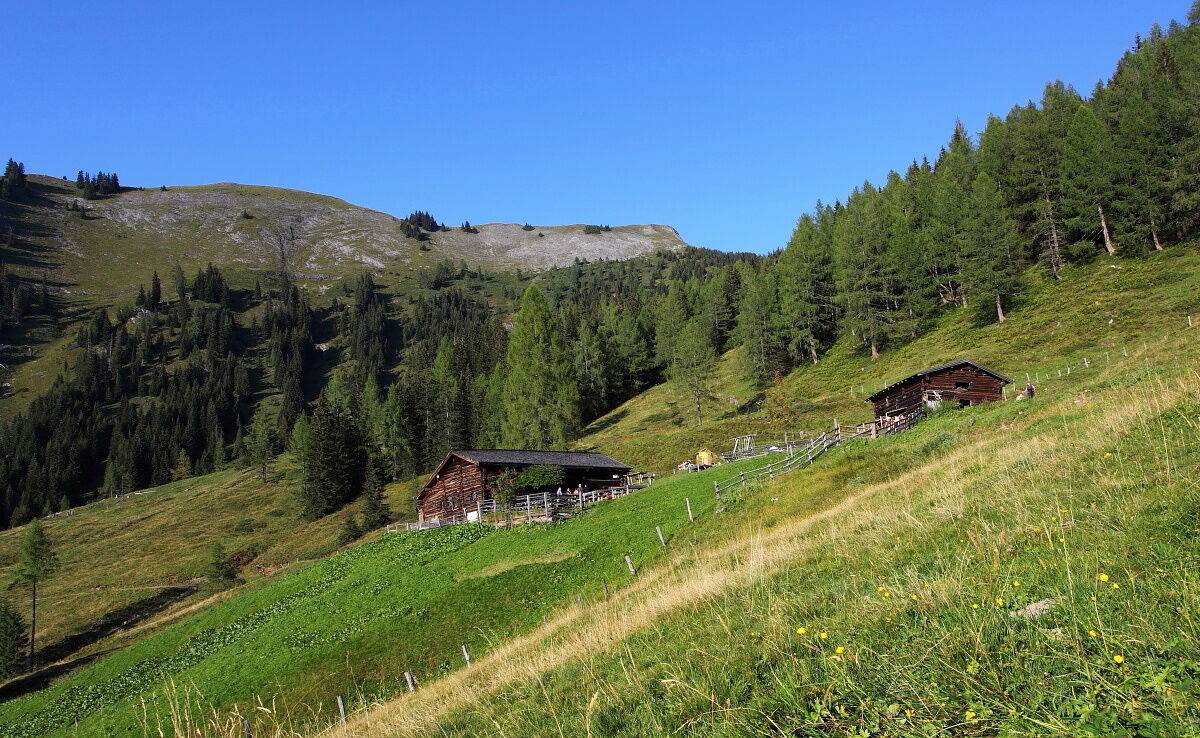
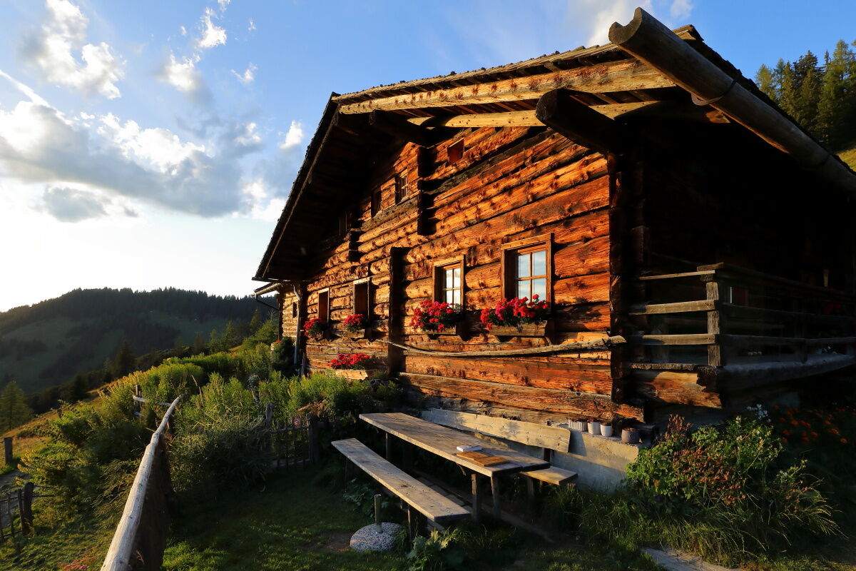
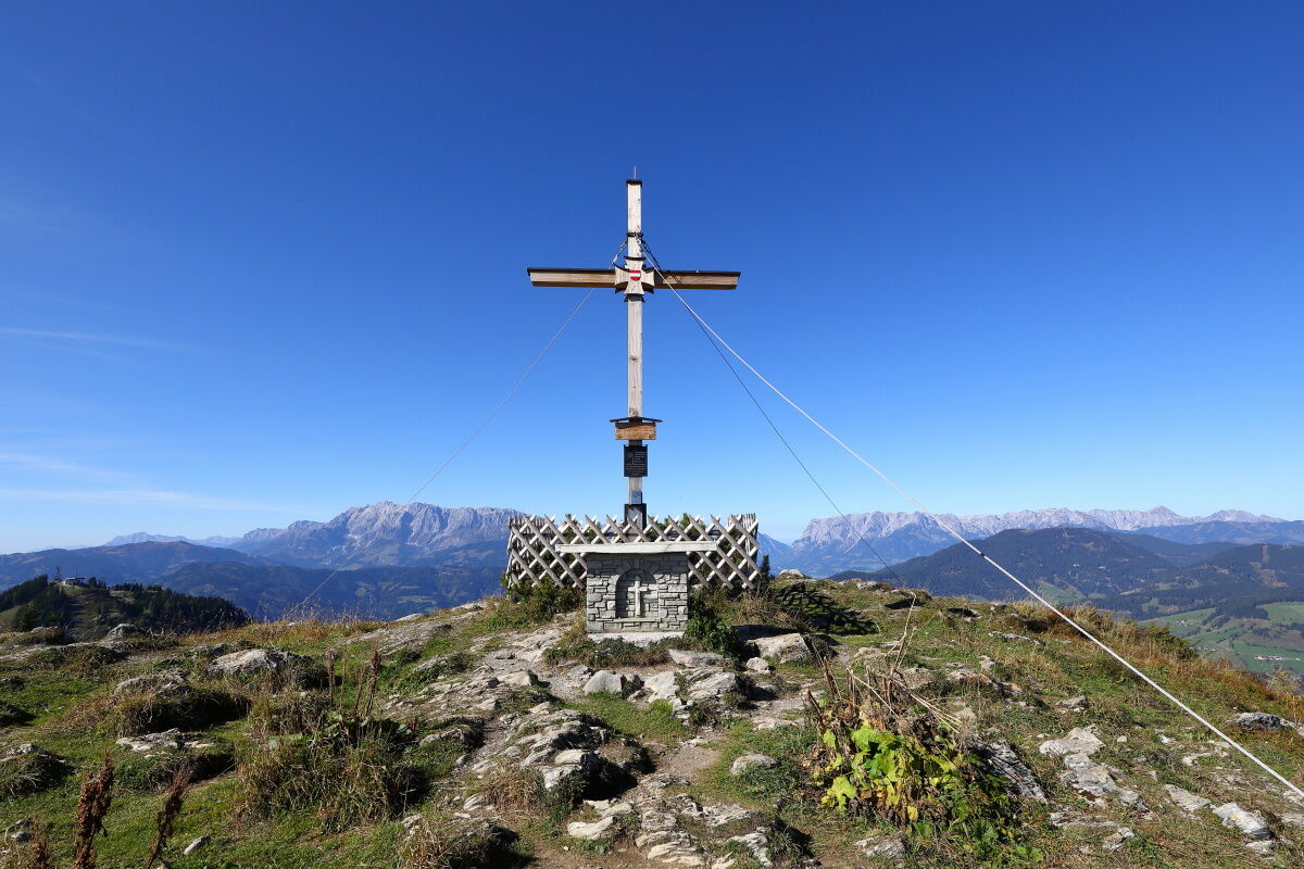
At 3,789 metres, the Großglockner is not only the highest mountain in Austria, but also a glacier experience full of outstanding radiance and magic. It forms the centre of the Hohe Tauern National Park and even from the Salzburger Almenweg you can see the striking summit. Today’s stage 13 offers a breathtaking view with Austria’s tallest paeak as a magnificent and ever-present sight. Just like the numerous other impressions such as smoke that rises curling from the chimneys of the alpine huts and summit crosses that stand out like miniatures in the sky. Filigree woolly grass, whose fine stems are dishevelled by the wind and alpacas that greet hikers curiously. With hut doors decorated with alpine roses and sour cheese with a unique aroma. Bleating goats and cows chewing again and again. This more than six hours long high-altitude hike through the north-eastern part of the Grossarltal is idyllic, not particularly strenuous, and a beautiful farewell gift. Because, after almost four days you leave the "Valley of the Alpine Pastures" and the path continues eastwards.
Along the trail
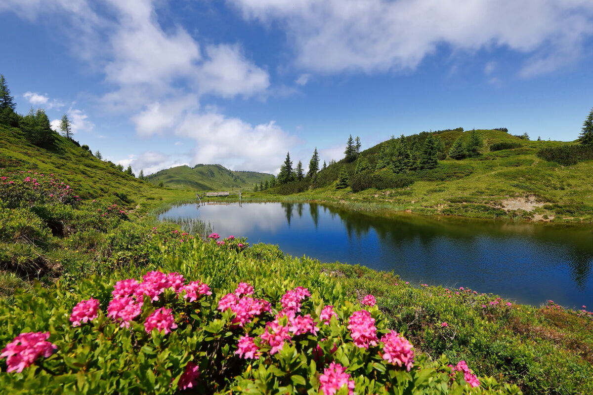
Small, deep black moor lakes can be found again and again in the mountains of Salzburg's Pongau region. Hikers know, for example, the raised bog on the Gerzkopf in Eben, the "Himmelsteiche" (heavenly ponds) on the Lackenalmen in Altenmarkt or the Trögseen Lakes in the Grossarltal. These 15 to 20 "black lakes" are distributed between the two ridges of the Grundgg. Around the moor lakes, fauna and flora unfold an extraordinary diversity with alpine roses, anemones, gentian, woolly grass and rare dragonflies. This unique natural landscape is undoubtedly one of the most beautiful parts of the entire Grossarltal.
Alpine Trail Refreshment
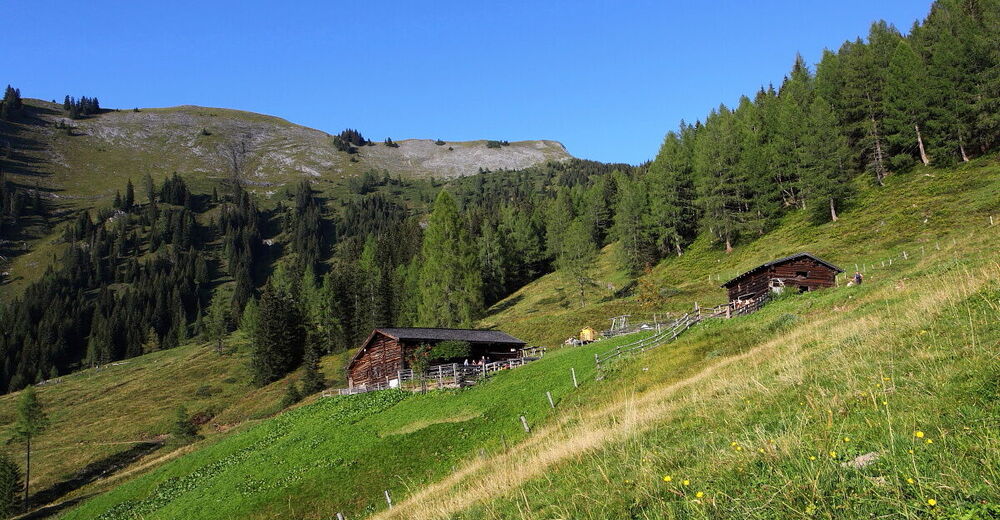
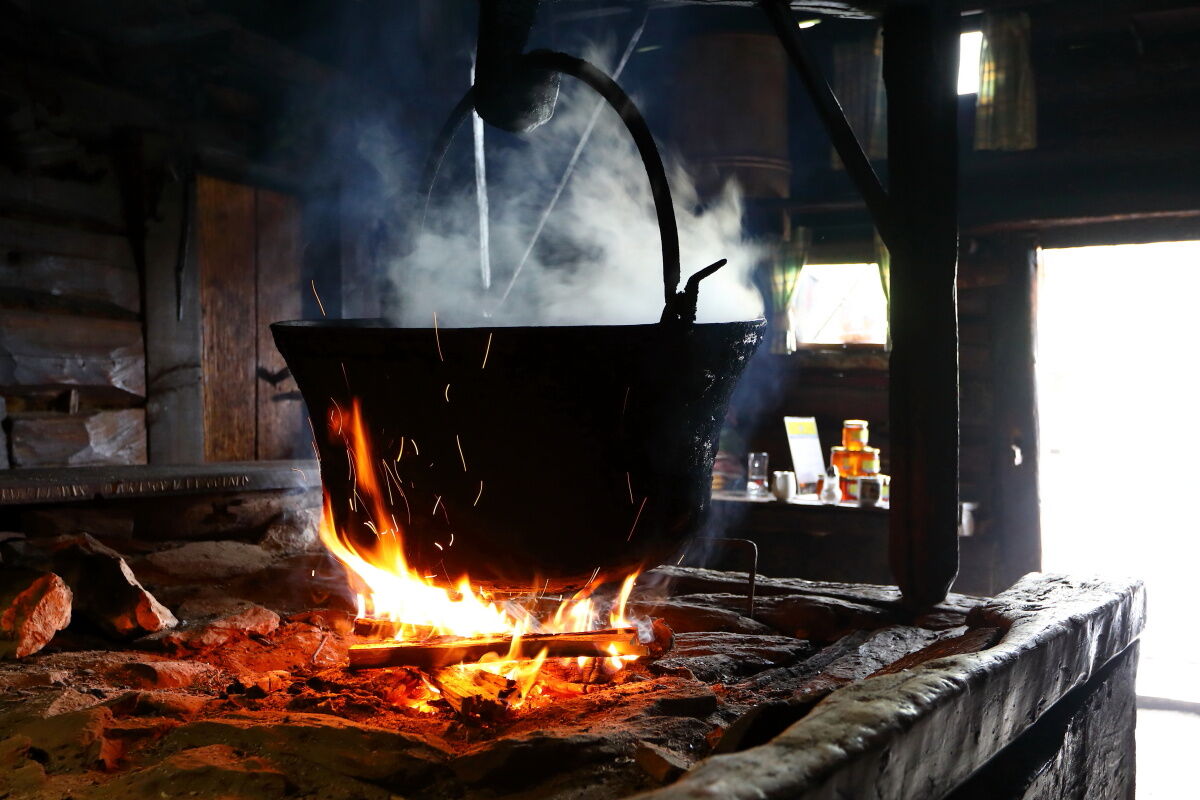
The 400 year old Karseggalm is the oldest hut in the Grossarltal and that's exactly what it looks like. A mighty Elder bush flanks the entrance decorated with alpine roses, smoke comes out of the open door and inside a fire flickers. An open fireplace with soot blackened timber, two kettles, one filled with cheese and the other with water, and the mashed clay soil are reminiscent of bygone times. On the beams above the fire, a Großarl speciality is maturing which is only produced here - the kneaded cheese, which is served like finely grated Parmesan with a Ploughman’s board or cheese snacks. Every Thursday, hikers can look over the dairywoman’s shoulders as she makes the cheese.
Almenweg Tip
The centuries-old Weißalm has been carefully restored: On the original, open fireplace, sour cheese was once produced for generations, which is made directly on the alp or on the farm, along with sausage, bacon, smoked beef, bread, butter and various schnapps. The affectionate equipment of the hut with old tools reminds of long past days and the laborious work in the mountains. In a showcase there is an amazing collection of rock crystals, which were found not far from the hut.
- Directions
-
From the Loosbühelalm, follow trail no. 63 slightly downhill to the north until it soon widens and after about 30 minutes of walking you reach the Weißalm, which also invites you to stop for a bite to eat and spend the night. From here, it is a good half an hour via path no. 63 slightly uphill to the Ellmaualm at 1,794 metres above sea level. On one of the highest alpine pastures in the Grossarl Valley, hikers are treated to homemade alpine delicacies.
At the crossroads at the alpine pasture, the alpine path continues straight ahead on path no. 63 at a constant altitude first to the unserviced Henerbichlalm and from there uphill to the 1,906-metre-high Kartörl, the highest point of today's stage. From the ridge you can see a summit cross in the east, a little off the main path. From there it is only a few minutes over to the "troughs". The detour of about a quarter of an hour to the moor lakes is absolutely worthwhile.
Back on the Salzburger Almenweg, take path no. 63 past the Karalm (here at the crossroads, choose the right path) steadily downhill to the Spatalm and from here at the same altitude to the Kleinwildalm, all three of which are not managed. After the Kleinwildalm, continue along trail no. 63, which runs at almost the same altitude, to the managed Großwildalm, from where two trail variants open up. Either you continue to follow the goods road downhill and take the road to the Karseggalm on the right at the third hairpin bend or – and this is our tip – follow the idyllic trail from the Großwildalm down towards the Breitenebenalm. After just under an hour, you reach a fork in the road and follow the path up to the Karseggalm, which leads first through a beautiful spruce high forest and then over wide alpine pastures. (The Breitenebenalm could be reached from the fork in the road mentioned above in a quarter of an hour.)
The 400-year-old Karseggalm is one of the oldest huts in the valley. From there, you can reach the Unterwandalm in about 20 minutes via hiking trail no. 70 at a constant height and - now via a goods road (no. 70) - in another hour or so to the Muggenfeldalm (not managed). Soon after, in the same direction, you reach the Maurachalm, the northernmost alpine pasture in the Grossarl Valley.
From there, follow trail no. 71 to the north for a long time at a constant altitude (ignoring paths branching off to the right and left) and finally a forest path until you reach the western ridge of the Sonntagskogel and today's stage destination, the Gernkogel, appears in your field of vision. The trail leads a short distance downhill in a westerly direction below the idyllically situated reservoir "Sonntagskogel" and then ascends again to the summit of the Gernkogel, today's stage destination.
Zur Übernachtung bieten sich zwei Möglichkeiten an:
Haibenalm: Diese bewirtschaftete Alm liegt östlich unterhalb des Gernkogels und ist vom Speicherteich „Sonntagskogel“ über einen Güterweg in wenigen Minuten erreichbar. Die Alpendorf Gondelbahn führt hinab nach ins St. Johanner Alpendorf, wo genächtigt werden kann.Variant 13a with descent to St. Johann or Wagrain:
If you prefer to spend the night in the valley, take the cable car to St. Johann or to Wagrain. From the Sonntagskogel, the descent to the mountain station of the Grafenbergbahn (Wagrain) goes south, where at the junction, follow the path to the right towards the mountain station. The mountain station of the Alpendorf cable car to St. Johann is about 45 minutes' walk below the Gernkogel. Please note the opening hours of the cable cars. The next day you can reach the stage start again with the cable car.
Variant 14b with stage shortcut directly to Kleinarl:
On tomorrow's stage 15, there will be a short, black section on the Kitzstein ("fork"), which requires a bit sure-footedness and a head for heights. For those that don't dare to do this, you can combine stages 14 and 15 and hike to Kleinarl today. This variant leads from the Karseggalm over the Almsteig (Path no. 72) up to the unmanaged Karsegg-Hochalm and on to the ridge. The descent leads over the hiking trail No. 712 to the Kleinarler Hut, which can be reached in a good 1.5 hours on foot, and on to the stage finish at Kleinarl (see stage 15 description).
Refreshment and accommodation options
Weißalm (1.724 m), (after approx. ½ hour) Mid-June to mid-October, Tel.: 06414/411 or 0664/437 80 20 refresh. / accomm.
, T. +43 6414 411 oder +43 664 437 80 20 E/Ü
Ellmaualm (1.794 m), (after approx. 1 hour) mid of June to the end of October, T. +43 664 455 0411 E/Ü/Almsommerhütte
Großwildalm (1,787 m), (after approx. 3 hours) July to the end of August, Tel.: +43 6414 333 or T. +43 650 22 400 90 refresh.
Breitebenalm (1,420), (after approx. 4 hours) beginning of May to end of October, Tel.: (Gastronomy) +43 6414 81445, Tel.: (accommodation) +43 676 411 6787 refresh. / accomm. / Alpine summer hut
Karseggalm (1,603 m), (after approx. 4 hours) end of June to end of October, Tel.: +43 664 915 07 17 or +43 664 9962188 refresh. / Alpine summer hut
Unterwandalm (1,600 m), (after approx. 4.5 hours) mid-June to early October, Tel.: +43 664 2412908 or +43 664 453 64 38 refresh. / accomm. / Alpine summer hut
Maurachalm (1,620 m), (after approx. 5 hours) Early June to mid-October, Tel.: +43 6414 293 refresh. / Alpine summer hut
Haibenalm (1,650 m), (after approx. 6.25 hours) June to mid- September, Tel.: +43 664 266 98 07 or +43 664 588 37 32 refresh. / accomm. / Alpine summer hut
Buchauhütte (1,750 m), (after approx. 6.5 hours), June to October (as Gondelbahn Alpendorf), Tel.: +43 664 2801508 refresh.
Gernkogelalm (1,750 m), (after approx. 6.5 hours) June to October (as Gondelbahn Alpendorf), Tel.: +43 664 2669807 refresh.
Numerous places to stop for refreshments an overnight stays in St.Johann/Alpendorf, www.josalzburg.com refresh. / accomm.
Accomodation Partner Salzburger Almenweg Information and Booking Centre powered by Trail Angels: Hotel AlpenSchlössl, more information: https://www.hotel-alpenschloessl.at/, T. +43 6412 40 600
- Highest point
- 1,907 m
- Endpoint
-
Gernkogel (1.787 m), St. Johann in Salzburg
- Height profile
-

- Safety instructions
- Tips
-
Companionship has always played an important role on the alpine pastures, where people liked to sing, make music and taste Schnapps. Just like on the Unterwandalm and on the Maurachalm. Sometimes here, the accordion is unpacked or a voice rises to a joyful yodel, alpine song or whoopee.
The 400 year old Karseggalm is the oldest hut in the Grossarltal. An open fireplace with soot blackened timber, two kettles, one filled with cheese and the other with water, and the mashed clay soil are reminiscent of bygone times. On the beams above the fire, a Großarl speciality is maturing which is only produced here - the kneaded cheese, which is served like finely grated Parmesan with a Ploughman’s board or cheese snacks. Every Thursday, hikers can look over the dairywoman’s shoulders as she makes the cheese.
- Additional information
- Public transportation
- Parking
-
If you arrive by car, you can park it free of charge in the town centre parking lot near the ENI Petrol Station or at the car park Grundlehen in Ellmautal for several days. Please leave the "Salzburger Almenweg parking disc" from the brochure in your parked car!

- Author
-
Salzburger AlmenwegThe tour Salzburger Almenweg - Stage 13: Loosbühelalm - Gernkogel/St. Johann is used by outdooractive.com provided.