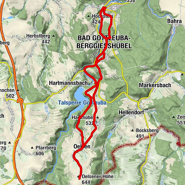
Hike on the Montanhistorischer Wanderweg: from Berggießhübel via Bad Gottleuba to Oelsener Höhe and back


- Brief description
-
...from Berggießhübel via Bad Gottleuba to the Oelsener Höhe and back.Historical events up close - that's what awaits the hiker on this tour. Especially on the way from Berggießhübel to Bad Gottleuba and further to the Kulmer Steig, you will be transported back into mining history. The highlight in the truest sense of the word is the ascent to the Oelsener Höhe, the highest elevation in Saxon Switzerland. The route back is slightly different via the Hohlen Stein and the Panoramahöhe.
- Difficulty
-
medium
- Rating
-
- Starting point
-
Berggießhübel
- Route
-
Sächsisches Haus0.3 kmBerggießhübel0.4 kmGiesenstein1.6 kmBad Gottleuba-Berggießhübel2.3 kmParkcafé „Alter Bahnhof“2.8 kmBad Gottleuba3.4 kmGasthof Hillig3.7 kmHammergut Haselberg5.0 kmOelsen9.5 kmOelsener Höhe (644 m)11.3 kmOelsener Höhe (644 m)11.5 kmOelsen13.5 kmBad Gottleuba19.5 kmParkcafé „Alter Bahnhof“20.2 kmBad Gottleuba-Berggießhübel20.6 kmPanoramahöhe (437 m)21.5 kmBerggießhübel23.0 km
- Best season
-
JanFebMarAprMayJunJulAugSepOctNovDec
- Description
-
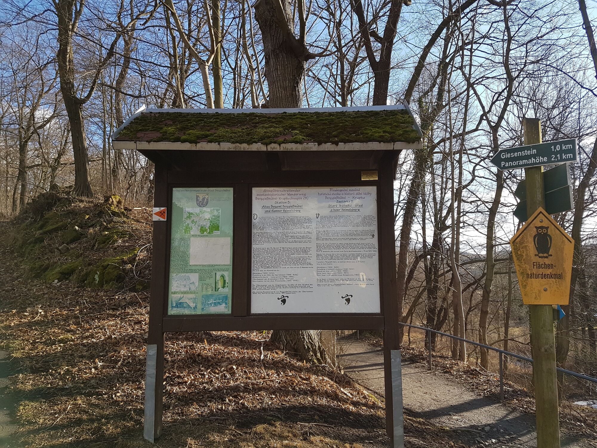
Marie-Louise-Stolln visitor mine - "Saxon House" - flood memorial - former Hänsel mill - Giesenstein Castle - Haselberg hammer estate - mound grave on the Kulmer Steig - road to Oelsen and Breitenau - new Oelsen cemetery - Oelsen church - Hohler Stein - (detour right up the slope in the direction of Panoramahöhe - Bismarck tower) - Berggießhübel - St. Peter's church Berggießhübel - starting point
- Directions
-
The hiking trail begins at the Marie-Louise-Stolln visitor mine next to the Gottleuba River. We follow the footpath to the road bridge over the Gottleuba to the former railway station and the hunt commemorating the last shift in Berggießhübler mining. The path leads along the Gottleuba, past the "Saxon House" to the "Johann-Georgen-Bad". On the left, behind the former railway line to Bad Gottleuba, is a small spa park called "Fritzegarten". On the right opposite is the beautiful castle of the former Friedrichsthal estate. The hiking trail continues along Kneippstraße, past the flood monument commemorating the flood disaster of 1927, to Kirchberg. In the night of 8-9 July, an entire row of houses next to the Gottleuba was washed away by a 4-metre high flood wave and 88 inhabitants drowned. We continue our walk over the Kirchberg, along the Poetenweg to next to the former Hänselmühle. Then the path branches off to the left from Poetenweg towards Giesenstein on the plateau. We go left along the edge of the forest or slope until we cross the path to the Panorama Heights, the so-called Hexenstufen. In the time of mining, a working path of the Gottleuba miners came down here from the Mother of God camp and led on to Giesenstein - the colliery path. Continue on the path along the edge of the forest down to Giesenstein. To the left of the path in the forest, you can marvel at the deep caves caused by the carters with the extensive ore transports from the ore camp to the smelters and hammers. In the past, the mine road was also used to transport iron ore (Iron Road).The hiking trail leads past Giesenstein Castle in the direction of Bad Gottleuba to the combined footpath and cycle path. We follow this path to the ascent to the Siedlungsweg, continue along this via Finkenweg, Goethepark to Badstraße and on to the market. A detour to the nearby church is also worthwhile. Now we cross the market, walk past a historic postal distance column and the church parish hall and finally reach the valley road to Hartmannsbach. Past the old Bähr mill to the turnoff to Hartmannsbach, we also catch sight of the Fischermühle. We follow the valley road along the Gottleuba to the Haselberg hammer estate.The hiking trail follows the road to Oelsen to the intersection with the old construction road ("An der Talsperre"). It crosses this road and follows the "Alten Oelsener Weg" in the direction of Oelsen, which is also a section of the old Kulmer Steig (Kulmer Steig is a synonym for transport connections from the Elbe valley across the eastern Osterzgebirge mountains to Kulm in Bohemia. It is an old road system of partly dilapidated and unpaved historical traffic routes). The hike leads past an old Bronze Age burial mound on the Kulmer Steig. Our path continues along the "Alte Oelsener Straße" to the road to Oelsen and Breitenau. Here we now have to walk along the road for a while. Our planned tour leads from the young cattle facility back along a hiking trail in the direction of the new Oelsen cemetery. From there we reach the beautiful village church along the road to Oelsen. Now we have to walk further along the Oelsen road, still on the route of the prehistoric Kulmer Steig, pass an old stone cross and finally arrive at the Oelsen Heights. Here is a good opportunity to have a nice picnic and enjoy the "mountain air" and the view a little longer. Once we are ready for the way back, we first walk back in the direction of Oelsen. At the Oelsen church, the path leads us to the left in the direction of the road. But we only cross this road and continue towards the Gottleuba dam until we reach the Hohlen Stein. Now the hiking trail continues along the dam in the direction of Bad Gottleuba. After a while, we again come to the junction between the Talstraße and the "Alte Oelsener Straße" or Kulmer Steig. This time we follow the "Alte Oelsener Straße" to the north and reach the Hellendorfer Straße, which leads further to Bad Gottleuba.Our path crosses Bad Gottleuba (again via the market), continues on the Pirnaer Straße and finally branches off to the right onto the Bahnhofstraße until it meets the Siedlungsstraße again, which we already walked on the way there. Those who are no longer fit can walk from now on in a similar way to the outward route and save themselves unnecessary metres of altitude. However, if you still want to enjoy a beautiful view, after a few more metres turn right up the slope towards Panoramahöhe and there you can enjoy a wonderful panoramic view over Saxon Switzerland from the Bismarck Tower. After this crowning conclusion to this strenuous tour, it is still about one kilometre back to Berggießhübel, where we reach our starting point again via Kirchberg and Pfarrweg (past the St. Petri church in Berggießhübel).
GPS data updated in 2022
- Highest point
- 643 m
- Endpoint
-
Berggießhübel
- Height profile
-
 © outdooractive.com
 - Equipment
-
Sturdy shoes required
- Safety instructions
-
Good physical condition
- Additional information
- Directions
-
A17 to junction Bahretal/ Berggießhübel, continue via Friedrichswalde/ Ottendorf and Cotta to Berggießhübel.
- Public transportation
- Parking
-
Parking lot - Berggießhübel, at Marie-Louise-Stolln


- Author
-
The tour Hike on the Montanhistorischer Wanderweg: from Berggießhübel via Bad Gottleuba to Oelsener Höhe and back is used by outdooractive.com provided.


General info
-
Sächsische Schweiz
1405
-
Erzgebirge
629
-
Bad Gottleuba-Berggießhübel
268