Aktiv im Sankt Wendeler Land III

Logo Aktiv im Sankt Wendeler Land III
Tour data
17.3km
321 - 487m
Distance
334hm
329hm
Ascent
04:00h
 
Duration
Brief description

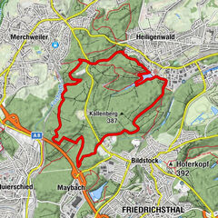
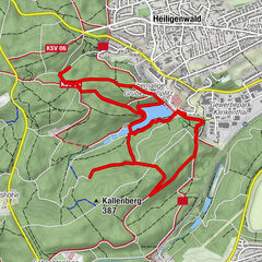
Diese anspruchsvolle Tour führt teils auf Asphalt, teils auf naturnahen Wegen zum Momberg, wo sich Reste eines keltischen Ringwalls befinden.

Rating
Technique
Fitness
Landscape
Experience
Route
Zur alten Ziegelhütte
1.1 km
Gronig
5.1 km
Orleheck
10.2 km
Zur alten Ziegelhütte
16.0 km
Best season
Jan
Feb
Mar
Apr
May
Jun
Jul
Aug
Sep
Oct
Nov
Dec
Highest point
487 m
Height profile
© outdooractive.com

Author
The tour Aktiv im Sankt Wendeler Land III is used by outdooractive.com provided.

Overall rating

5

0

%

4

0

%

3

0

%

2

0

%

1

0

%

Error
An error has occurred. Please try again.
Thank you for your review

Rating has been deleted

GPS Downloads
  • GPX GPS Exchange Format (XML)
  • KML Google Earth, Google Maps
QR Download Codes for Mobile Phones

General info

Cultural/Historical
A lot of view
Other tours in the regions

Popular tours in the area

Nordic Walking Park Kasbruchtal

Nordic Walking
4.8km | 45hm | 01:03h

Nordic Walking Park Itzenplitzer Weiher-Itzenplitzweg

medium Nordic Walking
6.88km | 125hm | 01:37h

Feilbach Tour - Nordic Walking Park Bexbach

Nordic Walking
10.01km | 103hm | 02:15h

Nordic Walking Park Itzenplitzer Weiher-Altsteigersweg

Nordic Walking
11.11km | 143hm | 02:21h