
- Brief description
-
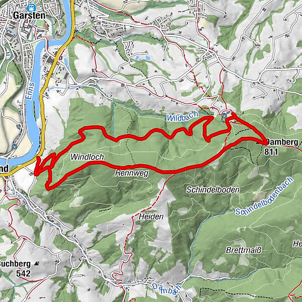
Circular trail from Landhotel Eckhard past Gasthof Schoiber to Dambergwarte and back via Rennweg
- Difficulty
-
medium
- Rating
-
- Starting point
-
St. Ulrich/Landhotel Eckhard
- Route
-
Windloch1.6 kmDamberg (811 m)4.8 kmDambergwarte4.9 km
- Best season
-
JanFebMarAprMayJunJulAugSepOctNovDec
- Description
-
Starting from the Landhotel Eckhard, the trail leads steadily up the Damberg, past the Gasthof Schoiber to the Dambergwarte and via the Rennweg back to the Landhof Eckhard.
Trail number: 12, E90, E97, 467
Variation:
Großes Hufeisen from the Gasthaus Schachner in Dambach to the Rumplhöhe, to the Sonnberg and over the Schwarzberg in the direction of the Damberg to the Dambergwarte (807 m) and back along the ridge over the Rennweg down to the Windloch and the starting point.
- Directions
-
The hike begins at the Gasthof Eckhard on the Eisenbundesstraße B115. Between the petrol station and a residential building, the trail leads to the Mayr farmhouse at Dambach. There, a forest road joins the asphalt road. Follow this for a short distance. This is the start of Alpine Club Trail No. 12, which leads us up to the Damber ridge.
After a short hour we reach the Windloch. A natural cave of which legend has it that it has a connection below the Enns to the former monastery of Garsten.
Following the Rennweg on the Damberg, we reach the 36 m high Dambergwarte after about 45 minutes. It offers a wonderful panoramic view.
From the lookout we hike along the northern slope of ÖAV trail 467 to the forest road, where we turn left to the Laurenzi Chapel, built in 1864. This is where the Bible Trail begins, which we follow to Gasthof Schoiber.
From there the trail leads a short distance on the Dambergstraße to the Kreuzleite, where a forest road branches off to the left. this leads along halfway up the Damberg and brings us back to our car park.
Variants: By car to Gasthof Schoiber and from there there are various circular hiking options on the Damberg.
Variante Großes Hufeisen: From Gasthaus Schachner via a short Steig into Kammergraberstraße to Danzbergergut and left via Wiesenweg into Buchbergstraße.
Continue via Reithuberstraße, Sturzberg to Rumpelhöhe and Sonnberg (777 m). Over the Schwarzberg (838 m) you then walk below the Braschenberg towards the Damberg (807 m) to the Warte with its magnificent panoramic view.
Return along the ridge via Rennweg down to Windloch. A natural cave of which legend has it that it has a connection under the Enns to the former monastery of Garsten. From Windloch it is not too far to the starting point.
- Highest point
- 805 m
- Endpoint
-
St. Ulrich/Landhotel Eckhard
- Height profile
-

- Tips
-
The numerous steps up to the Dambergwarte are rewarded with a magnificent view of the city of Steyr, into the Raming Valley and neighbouring Niederösterreich and into the Enns Valley and the Kalkalpen National Park.
- Arrival
-
From Salzburg/Linz: A1 motorway exit Enns-Steyr > B115 into the Enns Valley.
From Vienna: A1 motorway exit Haag > B42 > B122 > B115 into the Enns Valley
From Passau: A8 Passau > Wels > A1 motorway exit Enns-Steyr > B115 into the Enns Valley
From Graz: A9 Pyhrnautobahn > motorway exit Klaus > Grünburg > into the Ennstal valley
- Public transportation
- Parking
-
St. Ulrich/parking Landhotel Eckhard
- Author
-
The tour Circular Trail Damberg with Bible Path is used by outdooractive.com provided.


General info
-
Traunviertel
1961
-
Tourismusregion Bad Hall
776
-
St. Ulrich bei Steyr
294