
- Brief description
-
Mountain tour on well-marked and signposted trails, surefootedness required from the ascent to the Törl incl. some rope belays. An immensely rewarding day tour for mountain enthusiasts with stamina.
- Difficulty
-
difficult
- Rating
-
- Starting point
-
Micheldorf/parking near Kremsursprung
- Route
-
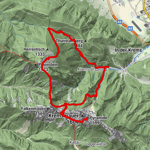
Törlspitze (1,510 m)3.3 kmTörl (1,457 m)3.4 kmKremsmauer (1,604 m)4.5 kmPyramide (1,599 m)4.6 kmNackter Kalbling (1,368 m)7.7 kmRauer Kalbling (1,381 m)7.9 kmGradnalm8.8 km
- Best season
-
JanFebMarAprMayJunJulAugSepOctNovDec
- Description
-
The starting point is the car park near the Kremsursprung near Micheldorf, a steep ascent follows to the Parnstaller Alm, after a longer traverse the trail goes up to the Törl.
The path to the rock gate between the Falkenmauer and the pyramid is secured with ropes. After a short descent, the last ascent follows to the magnificent summit of the Kremsmauer (1,604 m).
The next destination is the Gradnalm and from there the descent to the valley follows.
Trail number: K93/443, K93/445, 444, 446
- Directions
-
On the round tour over the Törl and on to the Gradnalm, however, there are a few more ascents, adding up to a total of 1400 metres in altitude.
The car park near the Kremsursprung near Micheldorf is the starting point of this circular trail. Following the signs, you cross the Krems and the path through the forest soon begins to climb steeply. High above a partly deeply cut ditch, the trail winds its way up.
Only in the area of the Parnstaller Alm does it flatten out and after a longer traverse you come to a crossroads and follow the sign up to the Törl.
Some steep passages are secured with ropes and you can reach the rock gate between Falkenmauer and Pyramide without any major problems. A nice place for a rest before descending about 100 metres in the direction of Steyrling to reach the magnificent summit of the Kremsmauer on the last steep ascent.
Deep down you discover the next destination of this mountain tour, the Gradnalm. Descend to the turn-off to Steyrling, climb back up to the Törl, down to the crossroads, which we already know from the outward route. From here, follow trail no. 444, which winds its way under the impressive rock walls of the Falkenmauer, turns north and always follows the ridge to the Gradnalm.
Wonderful views of the lonely forest landscape below the small peak of the Rauhen Kalbling are a first reward, the alpine meadows at the Gradnalm, glowing yellow with countless troll flowers, another and the cosy rest at the hut a third.
With renewed energy, the last descent into the valley is also manageable.
- Highest point
- 1,579 m
- Endpoint
-
Micheldorf/parking near Kremsursprung
- Height profile
-

- Safety instructions
-
Surefootedness and a head for heights required!
- Directions
-
From Vienna/Salzburg: A1 towards Linz > A9 Pyhrnautobahn - exit Inzersdorf.
From Linz: A9 Pyhrn motorway - exit Inzersdorf
From Graz: A9 Pyhrnautobahn > exit Klaus > federal road B 138
- Public transportation
-
Arrival with the Pyhrnbahn, there are stops in Schlierbach, Kirchdorf/Krems and Micheldorf.
Details at www.ooevv.at
- Parking
-
Micheldorf/parking near Kremsursprung

- Author
-
The tour Mountain tour on the Kremsmauer is used by outdooractive.com provided.