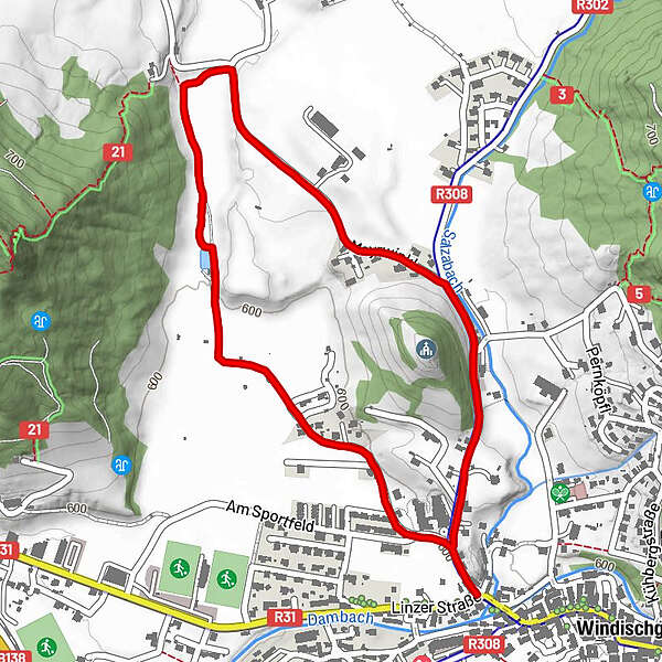
Rund um den Kalvarienberg

Logo Rund um den Kalvarienberg
Tour data
2.56km
594 - 618m
Distance
11hm
Ascent
01:00h
 
Duration
Brief description

Schwierigkeitsgrad: blau

Rating
Technique
Fitness
Landscape
Experience
Starting point

Ehemalige Gerberei Purgleitner

Route
Windischgarsten

Highest point
618 m

Rest/Retreat

Gastronomie in Windischgarsten

Ticket material

Wanderkarte Pyhrn-Priel erhätlich in allen Pyhrn-Priel Tourismusbüros!


Overall rating

5

0

%

4

0

%

3

0

%

2

0

%

1

0

%

Error
An error has occurred. Please try again.
Thank you for your review

Rating has been deleted

GPS Downloads
  • GPX GPS Exchange Format (XML)
  • KML Google Earth, Google Maps
QR Download Codes for Mobile Phones

Trail conditions

Asphalt
Gravel
Meadow
Forest
Rock
Exposed
Other tours in the regions

Popular tours in the area

Wurzeralm - Warscheneck

difficult Hiking
12.79km | 1053hm | 08:00h

Bosruck - Grenzberg mit drei Gipfelkreuzen

difficult Hiking
5.43km | 1005hm | 07:00h

Wörschachklamm

easy Hiking
4.67km | 266hm | 02:00h

Hinterstoder - Großer Priel

difficult Hiking
10.69km | 1993hm | 09:30h