- Brief description
-
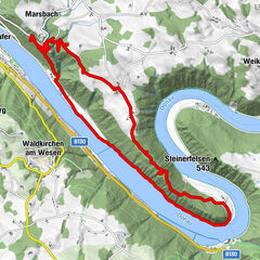
Hiking trail offering fantastic views of the Mühlviertel district, the foothills of the Alps and the Schlögen Danube Loop.
- Difficulty
-
medium
- Rating
-
- Starting point
-
St. Agatha
- Route
-
St. Agatha (603 m)Scharzeredt0.7 kmEtzing (615 m)1.7 kmBräuleiten3.0 kmMitterberg5.0 kmHauskapelle Hotel Donauschlinge5.8 kmSchlögen5.8 kmSchlögener Blick7.3 kmSchlögenleiten7.8 kmLinetshub8.4 kmDorf11.0 kmHaibach ob der Donau11.3 kmDonauleiten12.6 kmWiesing13.9 kmDunzing (536 m)17.4 kmMiniwirt19.4 kmSt. Agatha (603 m)20.5 km
- Best season
-
JanFebMarAprMayJunJulAugSepOctNovDec
- Description
-
From Kirchenplatz square we hike along Hauptstraße and take a right turn into Schulweg road. We hike past the secondary school and continue on a country lane. We hike northwards and get to Etzing, where there is also a Donausteig resting place. After Etzing we take a right turn and hike down towards the Danube. We leave the road at the last farm house and continue on a country lane and then through the forest down to Schlögen. We hike past Hotel Donauschlinge and up to Schlögener Blick vantage point. Then we continue on Ciconia Trail for a bit. We follow Donausteig Trail until we leave Haibach. In the Donauleiten hills we take a turn towards Wiesing and after a downhill section we cross the Nibelungen federal road. On the other side of the road we hike uphill again on a ski piste. We leave the forest at Dunzing and continue to hike through the cultured landscape. We pass the Fadinger monument and two guesthouses before we get back to St. Agatha.
- Highest point
- 625 m
- Endpoint
-
Ortszentrum St. Agatha
- Height profile
-

- Equipment
-
Standard hiking equipment
- Tips
-
Fantastic view of the Mühlviertel district and the foothills of the Alps
- Additional information
- Directions
-
By car:
... from Passau: take “Passau-Nord” or “Passau-Mitte” autobahn exit, toll free on Nibelungenstraße, B130 (approx. 40km);
... from Linz: toll free on the B129 past Eferding (B130);
... from Wels: toll free on the B137 or B134 past Eferding (B130);
St. Agatha is located at the southern bank of the Danube.By train:
... past Passau - Neumarkt - Grieskirchen - Linz;
The nearest train station is in Waizenkirchen (7km).
www.oebb.atBy boat:
... on the Danube: from Passau - Schlögen or Linz - Schlögen (Wurm + Köck shipping company)
www.donauschiffahrt.de - Parking
-
Municipality of St. Agatha


- Author
-
The tour St. Agatha: “Es muss sein” (“It has to be”) Trail is used by outdooractive.com provided.