© Verein Mühlviertler Granitland

- Brief description
-
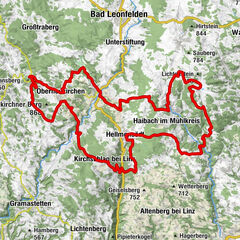
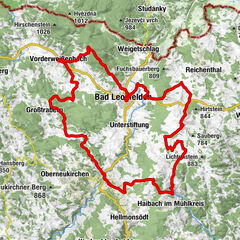
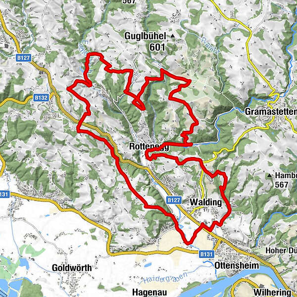
The tour leads up to panoramic heights and through five river valleys. You can start with parking in Walding at the Sportpark or in St. Gotthard at the Musikheim. Also at the sports field Rottenegg can be entered into the variant E1.
- Rating
-
- Route
-
Rodl0.9 kmSankt Gotthard im Mühlkreis15.4 kmMaierleiten22.7 kmRottenegg24.2 kmBach30.4 km
- Best season
-
JanFebMarAprMayJunJulAugSepOctNovDec
- Description
-
From the Walding Sports Park, the Rodltal tour leads past the Walding Zoo to the Mursberg, until a short single trail leads down to the Saurüsselbach and over the Oberstraßer Höhenrücken to the idyllic Eschelbach, where you meet the connection to the Granitlandrunde or Hansbergland-Südrunde. Further along the tour, the beautiful onion tower of the St. Gotthard church soon comes into view. From the valley of the Kleine Rodl, the route leads up to Limberg, where a breathtaking view of the Danube valley and the Alps can be enjoyed, before it goes down in serpentines to the Große Rodl and you can let the bike run easily to Rottenegg. But still in the village it goes up to the next viewpoint to Jörgensbühl and finally along the Brandstätterbach back to the sports park Walding.
The variant E1 leads from the parking lot in the Rottenegg sports field street over the old stone-paved trade route, the Krumauer Reichsstraße, to the Oberstraßer Höhenrücken and there joins the Rodltal tour E. If you finish this in Rottenegg, you are back at the starting point of the variant E1.
- Highest point
- 529 m
- Height profile
-

- Author
-
The tour MTB - Rodltal tour is used by outdooractive.com provided.
All ratings
Georg M.
09. Apr. 2024
Verified gone
Gute Tour auch mit dem Gravelbike machbar.
GPS Downloads


General info
A lot of view
Other tours in the regions