Donausteig Stage 3_N08 Steyregg - Mauthausen: „Danube rivers und hill country“


- Brief description
-
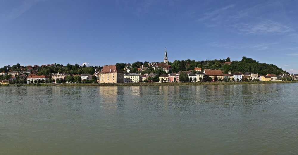
Donausteig-simply fabulous! This stage leads us from Steyregg at the edge of the Danube plain through the jungle-like Donauauen (plains), along the mighty Danube river current and the panoramic hills of the Mühlviertel (region) to Mauthausen on the Danube. We discover the medieval town Steyregg, the world of the "Danube" waterway, one of the most important places of worship of the Danube region, the atrocities of national socialism, Mauthausen as the center for granite Art...
- Difficulty
-
difficult
- Rating
-
- Starting point
-
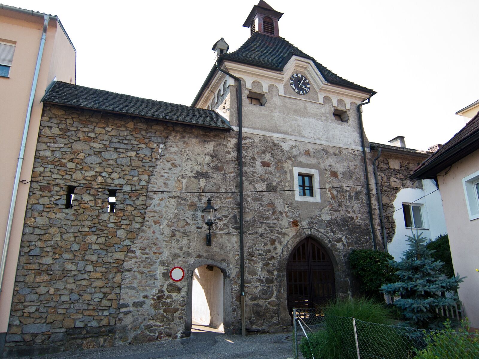
Steyregg-the Donausteig-starting point "Steyregg" lies on the east side of the tennis court's parking lots north of the Linzer main street
- Route
-
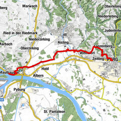
Gasthaus Weissenwolff0.0 kmSteyregg (259 m)0.0 kmSteyregg Ost0.2 kmCnario0.5 kmGusen11.3 kmKreuzmühle15.6 kmMarbach16.6 kmMauthausen20.3 km
- Best season
-
JanFebMarAprMayJunJulAugSepOctNovDec
- Description
-
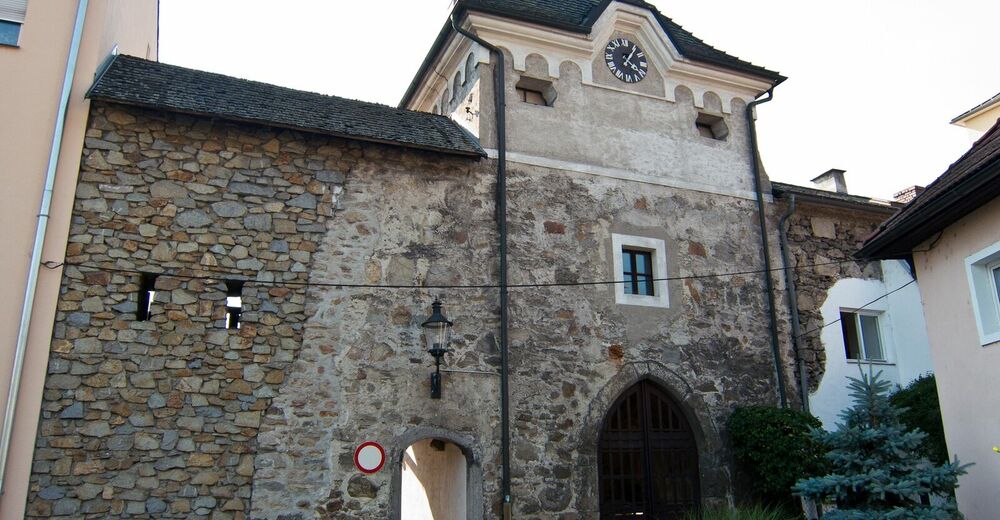
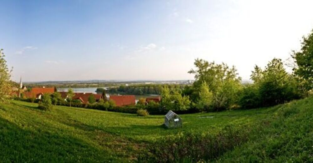
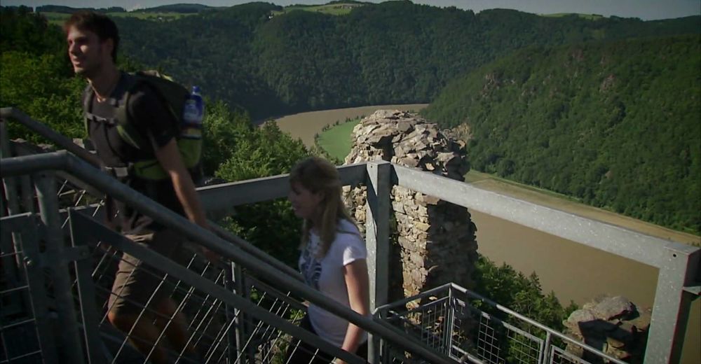
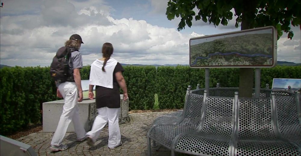
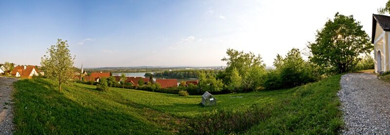
This Donausteig-stage starts in Steyregg. The historic town lies on the eastern edge of the Linzer basin, separated by wide floodplains from the Danube. The beautiful town enchants with its medieval atmosphere and at the same time it's mystery - see and discover! From the Donausteig-starting point, we first briefly wander through the city, then the old road leads for 1.5 km through the rural Danube plain. At the train station of Pulgarn, we turn towards the Danube. Now, a gravel road leads through a fascinating wetland: jungle-like forests, overgrown ponds, impressive tree giants, but also ponds and gravel-trucks. The bizarre atmosphere is reminiscent of the exploiting remote rainforests! Arrived at the Danube, we follow the paved Danube River Dam for several kilometres downstream. The current presents itself as a waterway of global stature, and as a playground for all kinds of adventurers: cyclists, canoeists,... - here we are among us! A short stretch before the power plant Abwinden-Asten we leave the Danube and cross its side arm. Now, a narrow road at the foot of the big road embankment of the main road leads for 2.5 km through dense lowland forests. Then we turn and strive toward the edge of the Danube plain. The riparian zone is soon behind us and we can walk over small farm roads through a nice rural cultural landscape to Gusen. Further on, we accompany the main street a short distance towards Langenstein. Here begins the climb into the wonderful Mühlviertler Hills - a scenic highlight! Meadows, woodland, farms, fields, wayside crosses,... provide rural creativity and long living tradition. On small farm roads we hike up the first Ridge, of the Frankenberg (mountain). Eyes wander up here to the wide plains of the Danube in the Mostviertel region and into the Traun-Enns-Riedel country - simply beautiful! After a short interim descent via farm and forest trails, we are on the opposite side of the former concentration camp Mauthausen. Monuments standing tall remind us of the horrors of this place. The question arises: "Can anything similar happy again today?" Thoughtfully we go down into the Rieder Bachtal (Valley) to the inn Kreuzmühlel, where we have the opportunity for a detour into the concentration camp Mauthausen. Further on, the Donausteig via a side road continues through a short section of forest and leads us up to the idyllic Castle Marbach. A few minutes later we are at the top standing next to a magnificent Lindenbaum (tree). Congratulations - this is the highest point of this Doinausteig-stage! Here the 360 ° view far deep into the country is truly a place of inspiration. Now, we wander on meadow, farm and forest paths lightly up and down to the Donausteig-resting point „Kalvarienberg-Kapelle“ on the last Ridge overlooking the Danube River. The views of the historic Ennsmündung (river mouth) allow us to philosophize about the passage of time. After a short descent through villages, we are at the magnificent waterfront of Mauthausen, the center for granite Art. The Donausteig - simply an experience!
Discover the following features with the Donausteig-diary:
-Steyregg-a new old town
-Donausteig-starting point "Steyregg"
-Ringelau-gravel from the jungle
-Traunmündung-salt & steel
-Au forests on course to Europe
-Danube power plant Abwinden-Asten
-In the field of the radar!
-Storage space as a new Habitat
- ...
Download: Donausteig-diary "Stage 3_N08 Steyregg Mauthausen" - yet to follow!
- Directions
-
From the Donausteig-starting point "Steyregg", a paved footpath leads East in a left arc around the old city wall to the Seiler gate (old city gate). There we turn right. Shortly thereafter, we arrive onto the Mauthausen road which brings us to the old main road in a long right-curve. Left we reach the train station of Pulgarn in around 1.5 km. We cross the tracks on the right and cross the new main road and follow to the right the dirt road up to the next crossing. A wide gravel road now to the left redirects us along the Au up to the Marina Steyregg. From here we walk the Treppelweg downstream for approximately 3.5 km along the Danube. At the road junction we leave the river on the left and cross the bridge in the direction of Abwinden. Immediately after the bridge, the Donausteig turns left loop under the bridge and continues along the route at the foot of the big dam straight through the riparian zone. After 2.5 km, we turn left. In a long curve to the right, we come to the edge of the Auwald (forest) in a peasant settlement (prehistoric sacrificial site Berglitzl). Here turn left. On small farm roads we continue walking through a rural landscape up to the main road in Gusen. We follow it shortly in the direction of Langenstein and then turn left into the Poschacherstraße (Avenue). Leisurely we continue uphill, passed the Poschacher natural stone works, and at the next crossroads turn right. At the following junction (granite monument) we walk left in an s-curve uphill to the gas pressure station (Linden trees, granite monument) at the Frankenberg (mountain). Turn right here. To the left a road leads directly to the next rapidly downhill in the town of Frankenberg. The local settlement road goes left uphill over into a forest path, which puts us in a curve to the right onto the next Ridge. At the top, on the edge (View of the concentration camp Mauthausen) turn left and then right again. First a dirt road, then a paved road lead down to the Inn Kreuzmühle on the Rieder Bach (stream) (a trip to the concentration camp Mauthausen is possible). We go straight uphill to the asphalt road. Past a short settlement, we reach Castle Marbach. Here turn back to the right. After about 200 m, the asphalt road end and we follow the dirt road left onto the top of the Hill (Lindenbaum (tree), the highest point on this Donausteig-stage). From here we continue on meadow trails down to a courtyard entrance, which we follow on the left through a wooded area to the asphalt road. Now turn right. After approx. 180 m we turn right again. Starting on a forest road, then over dirt roads we continue straight ahead, and after a final right we reach the settlement of Kalvarienberg, and the Donausteig-resting point „Kalvarienberg-Kapelle“. At the T‑junction turn left and in a high curve continue to the right up to the Parkstrasse (street). We follow this street left downhill and at the next crossing turn straight into the Brunngasse (alley). Now continue downhill to the T‑Kreuzung. Here, left and we are on the market square of Mauthausen. At its west edge we go to the Rathausgasse (alley) and continue straight down to the Schloss Pragstein (castle) and then turn left to the Donausteig-starting point "Mauthausen".
To facilitate the orientation, the Donausteig was provided with its own system of orientation - you will find the description here .
- Highest point
- 354 m
- Endpoint
-
Mauthausen - the Donausteig-starting "Mauthausen" is located at the Tourism Office (on the waterfront) southeast of Schloss Pragstein (castle) near the stone sculptures.
- Height profile
-

- Equipment
-
Sturdy shoes
- Tips
-
A detour to the concentration camp Mauthausen gives an impression of the true horrors of the second world war.
- Additional information
-
WGD Tourismus GmbH
Lindengasse 9
4040 Linz, Austria
Tel. +43(0)732/7277-800
Fax. +43(0)732/7277-804
info@donausteig.comMunicipal office Steyregg
Weissenwolfstr. 3
4221 Steyregg
Tel.: +43(0)732/640155
Fax: +43(0)732/640555
office@steyregg.at
www.steyregg.at
Tourism agency Mauthausen
Heindlkai 13
4310 Mauthausen
Tel.: +43(0)7238/2243 od. 2023-0
Fax: DW-51
mauthausen@oberoesterreich.at
www.tiscover.com/mauthausen
www.mauthausen.biz - Directions
-
The starting point of this stage is directly at the Linzer Main road, approx. 120 m east of the main access of Steyregg at teh Tennis courts on the north side (Navigation: A‑4221 Steyregg, Am Tennisplatz).
- Public transportation
- Parking
-
At the parking lot at the Donausteig-resting point you can park free of charge


- Author
-
The tour Donausteig Stage 3_N08 Steyregg - Mauthausen: „Danube rivers und hill country“ is used by outdooractive.com provided.


General info
-
Mühlviertel
1781
-
Linz & Region Linz
842
-
St. Georgen an der Gusen
203