Tour data
5.83km
489 - 512m
Distance
15hm
19hm
Ascent
01:29h
 
Duration
Brief description

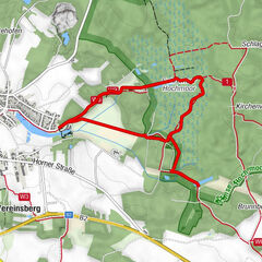
Rundwanderweg A in Gmünd

Difficulty
easy
Rating
Technique
Fitness
Landscape
Experience
Route
Gmünd NÖ (500 m)
0.0 km
Gmünd NÖ (NÖVOG)
0.1 km
Gmünd
1.4 km
Gmünd NÖ (500 m)
5.7 km
Gmünd
5.8 km
Highest point
512 m
Endpoint

Gmünd

Height profile

Author
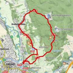
The tour Teichkettenweg is used by outdooractive.com provided.

Overall rating

5

0

%

4

0

%

3

0

%

2

0

%

1

0

%

Error
An error has occurred. Please try again.
Thank you for your review

Rating has been deleted

GPS Downloads
  • GPX GPS Exchange Format (XML)
  • KML Google Earth, Google Maps
QR Download Codes for Mobile Phones

General info

Refreshment stop
Other tours in the regions

Popular tours in the area

Hochmoor-Wanderweg ( Tut-gut Route 1)

easy Hiking
4.85km | 10hm | 01:30h

ZWalk - Gmünd - Marienkäferweg

easy Hiking
6.07km | 74hm | 02:00h

ZWalk - Zwettl - Zwei Flüsse Rundwanderweg

easy Hiking
11.48km | 141hm | 02:52h

Nebelstein 1017m

easy Hiking
6.08km | 271hm | 01:45h