


- Brief description
-
A pleasant all-day hike along the paths of the Viennese Alps and the Bahnwanderweg. Carry on past the Semmering railway, a UNESCO World Heritage Site, via the Kreuzberg, to Payerbach.
- Difficulty
-
medium
- Rating
-
- Starting point
-
Semmering railway station
- Route
-
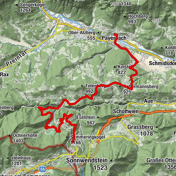
SemmeringKinderbahnhof Semmering0.3 kmSemmering - Kurort1.2 kmDoppelreiterkogel2.2 km20-Schilling-Blick2.8 kmAusschank Hinterholz4.6 kmFotopunkt Viadukt Kalte Rinne, Ghega Museum7.1 kmAdlitzgraben (Breitenstein)8.5 kmZum Blunzenwirt8.6 kmBreitenstein9.1 kmFilialkirche Breitenstein9.1 kmGasthaus Polleres Kreuzberg12.6 kmRichtung Klamm / Sonnwendstein13.4 kmKlammerkapelle14.6 kmKüb16.9 kmBarbarakapelle17.0 kmPfarrkirche Payerbach18.9 kmPayerbach19.0 kmPayerbacherhof19.1 kmPayerbach-Reichenau19.5 km
- Best season
-
JanFebMarAprMayJunJulAugSepOctNovDec
- Description
-
The Semmering Railway Route goes through two counties, connecting Mürzzuschlag in Upper Styria to Gloggnitz and Payerbach in the Schwarzatal valley in Lower Austria. This hiking tip covers the Lower Austrian part of Semmering to Payerbach, with a detour to reach Kreuzberg. Follow in the footsteps and trace the history of Carl Ritter von Ghega and his lifetime achievement: the Semmering railway (Semmeringbahn). Being on foot in this UNESCO World Heritage Site provides great views of deep valleys and shows the feats of engineering that were necessary to build a railway in this area. Attractive and leisurely hiking paths characterise this historic and cultural route in southern Lower Austria.
- Directions
-
This historic hiking route on the Bahnwanderweg starts at Semmering railway station. A few information boards at the start of the hike at the railway station tell us about the railway’s history and clarify the Viennese Alps route. Immediately left from the boards, we head uphill on a paved path and follow the first Bahnwanderweg signs towards Payerbach railway station. We approach the rails and the Ghega monument on the gravel path. Heading past a playground, we cross beneath the railway line and follow the school path to Wolfersbergkogel station. We ascend up the road and after turning left we continue straight ahead along a sandy path. The old Kurhaus Semmering spa building is in front of us, and is currently used for cultural events. After heading to the car park, we cross it and then carry on along the forest path before ascending to the Doppelreiterwarte observation point. The brief ascent to the observation point is well worth it.
Upon coming back to the path we head past the observation point on the right-hand side and return back in the direction of the Kurhaus car pack on a forest path that curves left. However, we don’t go there, but follow a path curving right towards which is known as the 20 Schilling view. If you ever held a 20 Schilling banknote between 1968 and 1998, then the view from the aforementioned site will be recognisable.
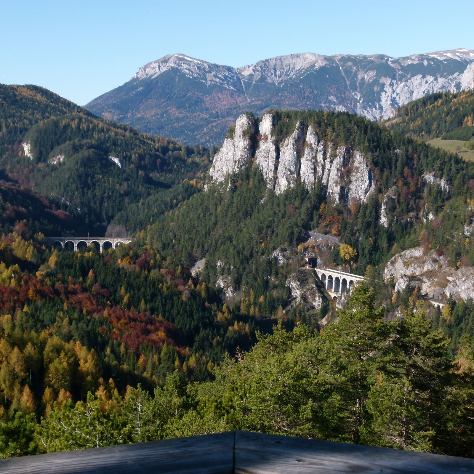
We follow the Viennese Alps until we reach a fork, and then turn right in the direction of Breitenstein. The next paved road is stayed on only briefly before turning right into the forest. After briefly coming back onto the road, we then turn right into Weberkogelstraße near the old steam laundry. If you’re feeling hungry and thirsty, the Hinterholz 9 refreshment point is a place to stop. We wander down to the viaduct in the lower part of Adlitzgraben, walk beneath the viaduct, and observe all tools that were used to construct the railway.
The route continues uphill along the road for a few minutes before turning left into the woods once more. Initially the route goes slightly downhill, then uphill past a large book describing the history of the Semmeringbahn (Semmering Railway). The woodland path becomes steeper and we follow a ridge which offers great views. The hiking route continues downhill to the Ghega Museum (open from 10am on Saturdays, Sundays, and holidays from May to the end of October). Back on the paved route, the Viennese Alps continue towards Prein, whilst we take Regional Route L on the road down towards Breitenstein.
At Blunzenwirt (closed on Tuesday and Wednesday) we turn left onto the Hauptstraße and follow the signs to Breitenstein railway station and go over a bridge. We then come across the Feuerwehrhaus on the road a bit further on, continue to ascend towards the municipal office, and then leave Hauptstraße and continue into Lindenstraße. After a short stretch we ascend along the road and turn slightly right into Untere Bahnstraße. We can look back towards Breitenstein and the Kalte Rinne viaduct. The paved road then becomes a cart path, which takes us uphill past meadows to a road with great views. At this point, head right and follow the road downhill then, when near some houses, turn into Blauer Einschnitt and get very close to the Semmering Railway once again. The Bahnwanderweg carries straight on to Klamm after a few minutes, however we turn left to Kreuzberg at the crossroads. Forststraße brings us to a road which leads us to the mountain ridges of the Kreuzberg. Gasthof Polleres is on the left if you fancy a hearty meal (closed on Mondays) and continue right on the gravel track. At the next crossroads, which has a plague memorial, we continue left along a gravel path. The views of Schneeberg and Rax are splendid at this point. When in the woods, we follow the path towards Klammer Chapel and go on a gentle climb. We turn left onto a hiking path marked in red at a point where the woods thin out somewhat. This narrow woodland route takes us downhill to Kochhof. A chapel and a large linden tree can be seen on the right, and we turn left into a cul-de-sac that goes towards Payerbach railway station and Küb post office (Postamt Küb). We are now on Regional Route M.
The asphalt road becomes a gravel track and we turn right at the first crossroads. Ignore the hiking route on the right and continue along the gravel track towards some houses. We leave the signposted Bahnwanderweg at the first crossroads with a red and grey hydrant and turn right. The road leads below the railway line and carries on to the historic Küb post office (open from May to October, Saturday and Sunday, from 10am to 5pm). Turn left at the house at Küberweg 2 a few metres further on to find the promenade to Payerbach. This forest promenade is now followed until the first houses in Payerbach are reached. We keep right and reach the centre, head past the church and then cross the Schwarza river. Go over the zebra crossing on the Bundesstraße and continue along the Bahnweg uphill to Payerbach-Reichenau railway station.
- Highest point
- 918 m
- Endpoint
-
Payerbach railway station
- Height profile
-

- Equipment
-
Always bring suitable maps. Always wear appropriate, sturdy footwear, bring sun and rain protection and water, as well as a little something to eat. Bring your mobile phone with you and save the mountain rescue emergency number: 140
- Safety instructions
-
Your hiking experience in the Vienna Alps should be a thoroughly enjoyable and safe one. Therefore, please bear the following in mind:
Preparation
When choosing a route, make sure it corresponds to your experience and physical fitness level. Check the weather forecast before you set off. The weather can change surprisingly quickly in the mountains. Always take appropriate equipment with you (e.g. rain protection).
Check whether the cabins and snack stations you intend to visit along the way are open. Inform someone before you set off of your chosen route and when you plan to return.
- Tips
-
Arrive the day before and start this day of hiking well rested after a hearty breakfast. The Doppelreiterwarte observation point offers a splendid panoramic view of the area between Semmering and Schneeberg. A place to eat and stay in Breitenstein is the Gasthaus zum Blunzenwirt (closed Tuesday and Wednesday) and the Pollereswirt in Kreuzberg (closed on Monday). The historic Küb post office can be seen on weekends between May and October.
- Arrival
-
From Vienna Travel along the A2 Südautobahn, change to the S6 Semmering-Schnellstraße and take the Maria Schutz exit. Turn right onto the L4168. Continue on Semmering/L4168 and Semmeringstraße. Turn right onto Bahnhofstraße.
From Graz Travel via the S6 Semmering-Schnellstraße and take the Spital/Semmering exit. Turn left onto Semmering Ersatz Str./B306. Straight ahead on the B306. Carry straight on through the roundabout towards Semmering. Continue along Passstraße, this heads slightly to the right and into Semmering. Turn left onto Bahnhofstraße.
- Public transportation
- Parking
-
Free parking is available at Semmering railway station.
- Author
-
The tour On the Bahnwanderweg hiking route from Semmering to Payerbach is used by outdooractive.com provided.


General info
-
Hochsteiermark
4081
-
Semmering - Rax
2312
-
Breitenstein
866


