The “Erzherzog Johann” circular hiking trail – Scheiblingkirchen


- Brief description
-
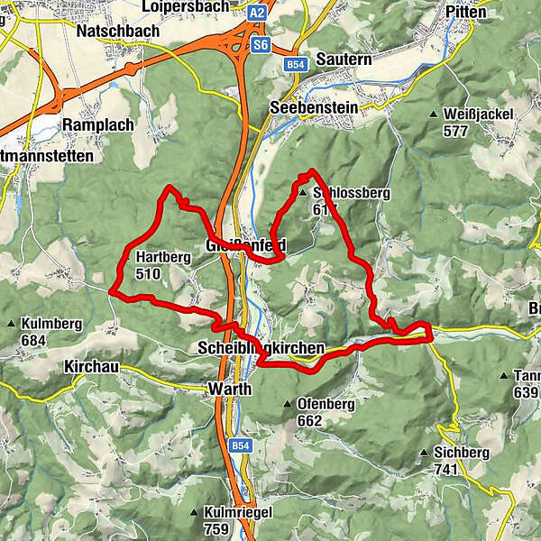
The extensive circular hike leads from the centre in Scheiblingkirchen via Gleißenfeld up to the “Türkensturz” and back via Thernberg. The leisurely hiking tour progresses mostly on well-surfaced paths, and partly on trails.
- Difficulty
-
medium
- Rating
-
- Starting point
-
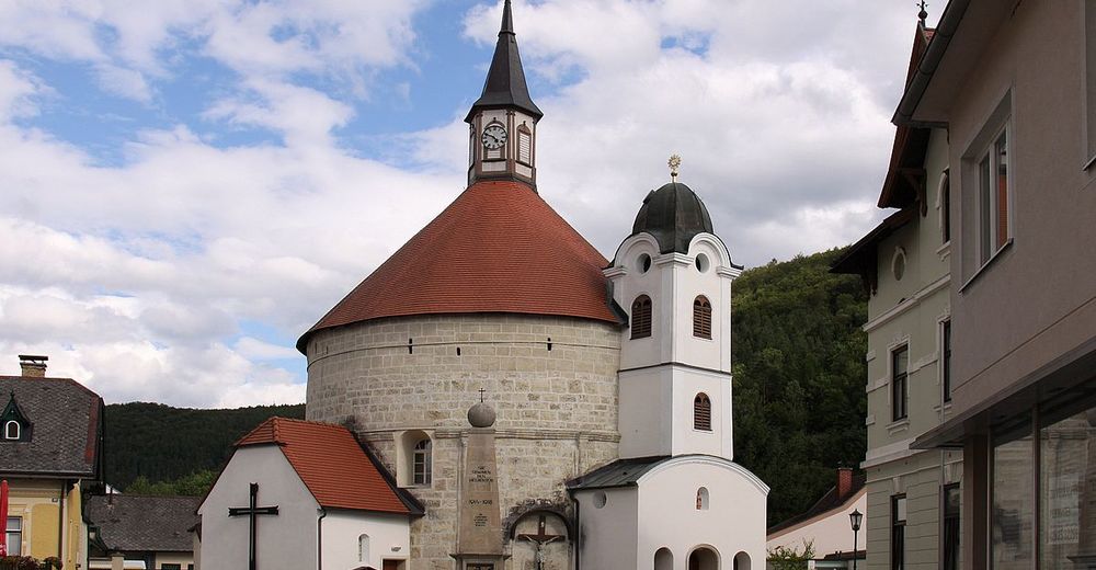
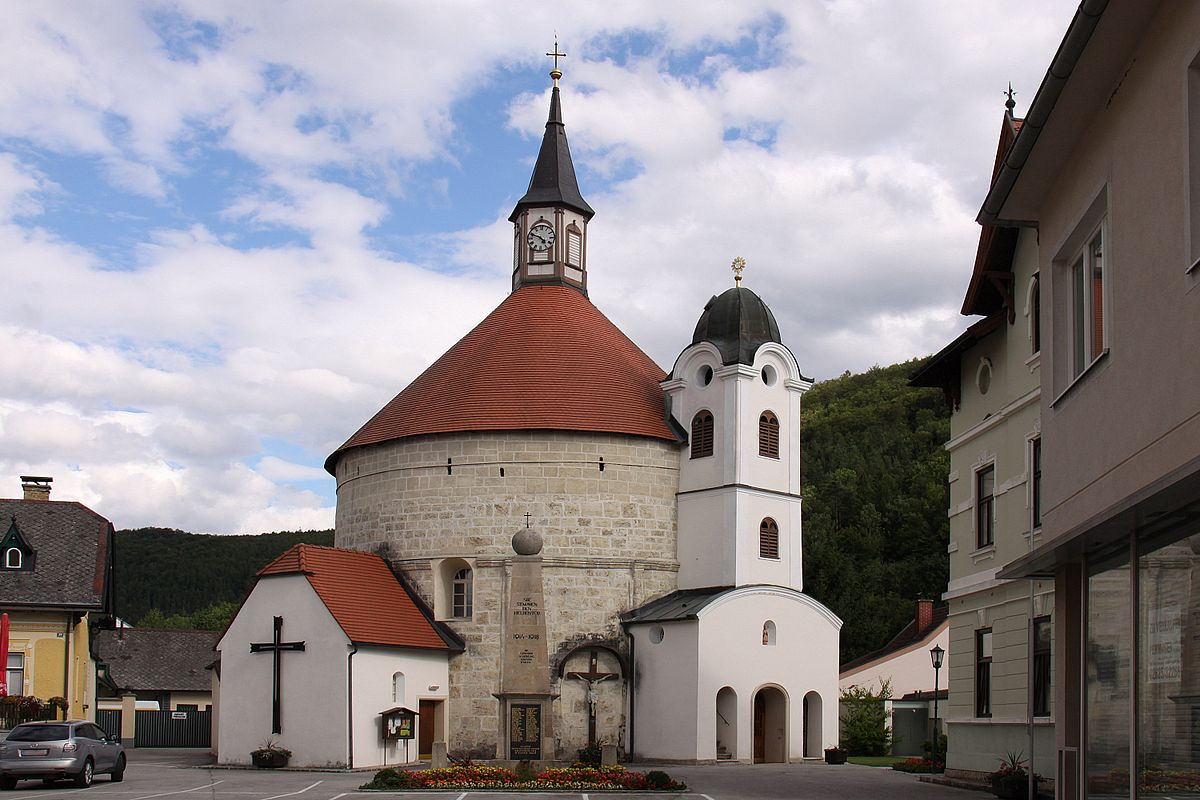
Scheiblingkirchen/ Parish Church
- Route
-
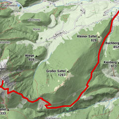
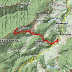
Pfarrkirche Scheiblingkirchen0.0 kmScheiblingkirchen0.1 kmWitzelsberg2.2 kmHartberg (510 m)4.7 kmHubertusbrunnen6.9 kmWaldkapelle "Maria im Walde"6.9 kmMaria-Hilf- und Florianikapelle8.6 kmGleißenfeld8.7 kmSchwarze Höhle10.1 kmTürkensturz10.1 kmWeingart14.6 kmNeustift15.3 kmLandgasthaus Thaler16.8 kmPfarrkirche Unbefleckte Empfängnise Mariens16.8 kmThernberg16.9 kmGasthaus Wöhrer18.2 kmInnerschildgraben18.2 kmScheiblingkirchen20.7 kmPfarrkirche Scheiblingkirchen20.7 km
- Best season
-
JanFebMarAprMayJunJulAugSepOctNovDec
- Description
-
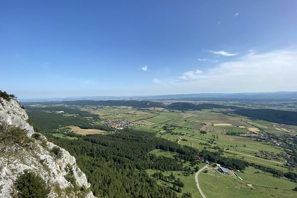
At the beginning of the hike, you can find a source of strength and peace in the unique Romanesque round church. From the main square in Scheiblingkirchen (370m above sea level) continue through the Höllgraben to Witzelsberg to the Heimkehrerkreuz. Then, through the forest to “Rehgartlkreuz”, over the Hartberg to the “Hubertuskapelle” (forest chapel), out to Gleißenfeld to the foot of the “Türkensturz”. At the first wooden arrow in the direction of Sollgraben, turn left and walk steeply up to the Türkensturz and over the Sollgrabenalm to Weingart. Then to Thernberg and back to Scheiblingkirchen.
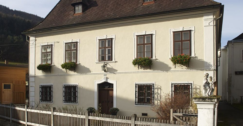
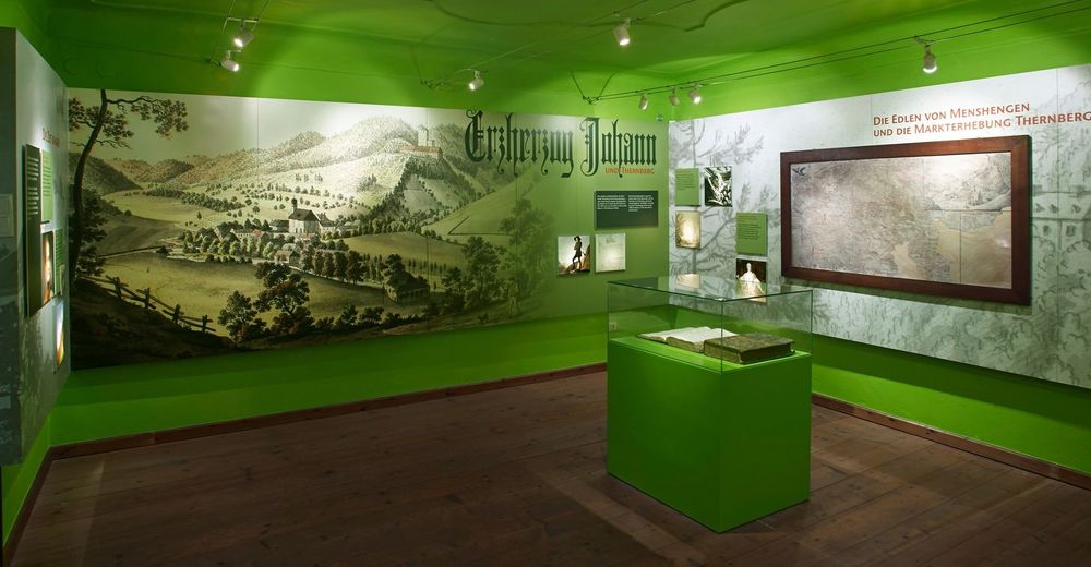
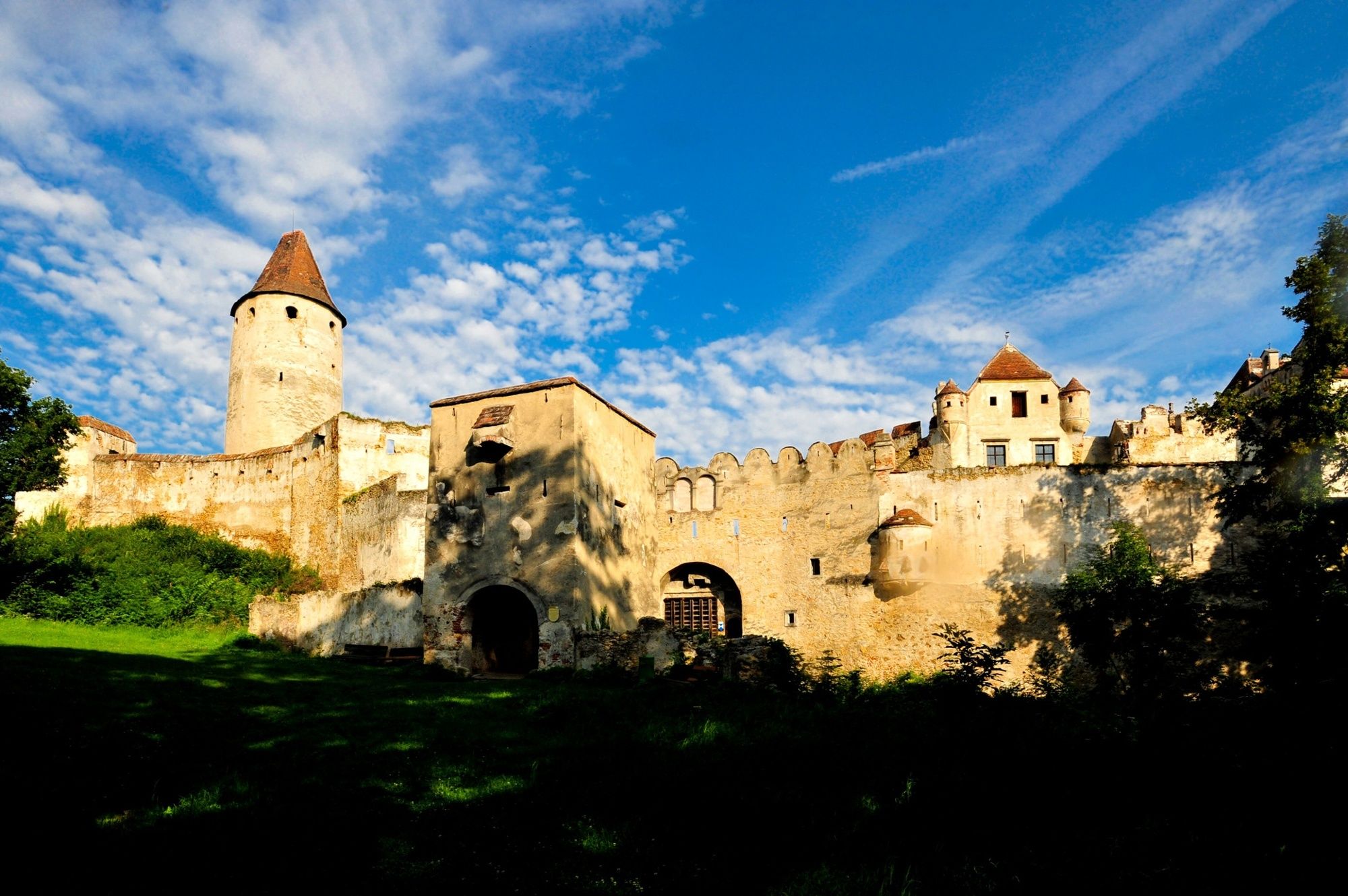
The namesake of this varied hike, “Erzherzog Johann” or “Archduke Johann”, is appropriated for many things – it is here that its use is actually justified: in 1807 he bought Thernberg Castle and kept it for 20 years. He was the first to engage in fruit tree cultivation here, and he proved to be a benefactor of the village many times. A documentary about “Hanns der Ternberger” can be seen in the former sacristan’s house in Thernberg by appointment.
One contrast to this is the story of the fall of the Turks: in 1532, local peasants here chased a scattered group of mounted Turkish soldiers up the hill between Gleißenfeld and Seebenstein. In an attempt to escape, the Turks fell to their deaths over the rocky precipice. To commemorate this, the owner of the Seebenstein estate had an artificial ruin built on the hill in 1825.
- Directions
-
We start at the church in the centre of Scheiblingkirchen, and walk left along the main road towards the railway station. At Reisenbauer, we turn right and then left onto the road under the motorway bridge. We now follow the road through the Höllgraben to Witzelsberg. In Witzelsberg, we turn left and, after about one kilometre, we branch off the road to the left onto the path. This leads us to the Rehgartlkreuz (481 m). From here, we continue to the right along the path to the Hartberg (510 m). Continuing straight ahead, we reach a road, which we follow for about a kilometre. Then we turn right towards “Hubertuskapelle” (forest chapel). Past the chapel, the path leads us down to Gleißenfeld. We follow the road through the village to the foot of the Türkensturz. At the first wooden arrow, we turn left up towards Sollgraben. The steep ascent leads us up to the “Türkensturz”. Via the Sollgrabenalm we go back down to Weingart and via Neustift to Thernberg. In Thernberg, after the “Erzherzog Johann”, we turn right onto Markt and keep to the right to get onto the hiking trail. The trail leads straight on via Innerschildgraben back to Scheiblingkirchen.
- Highest point
- 615 m
- Endpoint
-
Scheiblingkirchen/ Parish Church
- Height profile
-

- Equipment
-
Always take suitable maps with you. Wear sturdy shoes suitable for the tour, take sun and rain protection as well as water and a snack with you. Take your mobile phone with you and save the emergency number of the mountain rescue service: 140
- Safety instructions
-
Your hikes in the Vienna Alps should be an all-round beautiful and safe experience. Therefore, please note the following:
Leisurely hiking tour largely on well-surfaced paths, partly on trails. A steep path leads to the Türkensturz, but this can be bypassed via the Sollgraben road to the barrier in the direction of the Türkensturz.
Preparation
When choosing a route, make sure it suits your experience and condition. Check the weather forecast in advance. The weather can change surprisingly quickly in the mountains. Therefore, always set off equipped accordingly (e.g. rain protection).
Check whether the inns and snack stations you want to visit on the way are open. Inform someone about your choice of route and your planned return before you set off.
- Tips
-
There are fantastic views from the “Türkensturz” ruins!
- Additional information
-
Support points:
Gasthaus Reisenbauer in Scheiblingkirchen, www.gasthaus-reisenbauer.at Tel. 02629 / 24 01
Gasthof „Zum Wöhrerwirt“ in Innerschildgraben, www.woehrer-gasthaus.at Tel. 02629 / 22 65
Landgasthaus Thaler in Thernberg, www.landgasthausthaler.at, Tel. 02629 / 36 11
Further information:
Tourismusverband Bucklige Welt, www.buckligewelt.info Tel. 02643 / 70 10-19,
Wiener Alpen in Niederösterreich, www.wieneralpen.at, Tek. 02622 / 78960
- Directions
-
From Vienna: A2 – Seebenstein exit – B54 in the direction of Aspang/Pittental to Scheiblingkirchen.
From Graz: A2 – Exit Petersbaumgarten – B54 to Scheiblingkirchen.
- Public transportation
-
From Vienna or Graz via Wiener Neustadt take the regional train (direction: Aspang Markt) to Scheiblingkirchen- Warth station. From there, it is about a 7-minute walk to the starting point.
More information at www.oebb.at and www.vor.at
- Parking
-
Parking spaces are available at the main square in Scheiblingkirchen.

- Author
-
The tour The “Erzherzog Johann” circular hiking trail – Scheiblingkirchen is used by outdooractive.com provided.