© Waldviertel Tourismus - Destination Waldviertel


- Difficulty
-
easy
- Rating
-
- Route
-
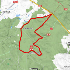
VitisPfarrkirche hl. Bartholomäus0.0 kmGasthaus Pichler0.2 kmTeichfeld2.6 kmGASTHAUS Weber Alfred3.3 kmJetzles3.5 kmStoies4.4 kmOrtskapelle4.5 kmGrafenschlag6.3 kmAlte Wege7.0 kmSchacherdorf8.1 kmEhem. Mautkapelle9.5 kmVitis9.8 km
- Best season
-
JanFebMarAprMayJunJulAugSepOctNovDec
- Highest point
- 583 m
- Endpoint
-
Vitis
- Height profile
-


- Author
-
The tour Teichweg is used by outdooractive.com provided.
GPS Downloads


Other tours in the regions
-
Waldviertel
1776
-
Oberes Waldviertel
614
-
Vitis
129