© MBN Tourismusmanagement GmbH - Moik / Nationalpark Nockberge


- Brief description
-
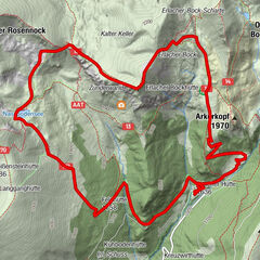
Eine Wanderung mit einem nicht einfachen Aufstieg bis zum Klomnock (2331m). Weiter geht eine panoramareiche Gipfelwanderung bis zum Mallnock (2226m). Über die Nordseite des Klomnocks komme ich wieder zum Ausgangspunkt.
- Difficulty
-
medium
- Rating
-
- Starting point
-
Glockenhütte
- Route
-
Glockenhütte (2,024 m)Klomnock (2,331 m)1.4 kmMallnock (2,226 m)3.1 kmGlockenhütte (2,024 m)7.5 km
- Best season
-
JanFebMarAprMayJunJulAugSepOctNovDec
- Directions
-
A marked hiking trail leads from the Glockenhütte mountain hut in the direction of Klomnock. Along the path, hikers are rewarded with wonderful views of Lake Windebensee. Once you have reached Klomnock, join Trail no. 161, which continues along the mountain ridge to Mallnock. Here you can enjoy an impressive view of Großer Rosennock (the highest peak of the Nockberge mountains). Continue to Brunnachgatter and follow Trail no. 1614 to the “Rote Burg”, a dolomite rock formation containing iron that glows red in the sun. From here, you can follow Trail no. 15 over Hoher Steig and back to the Glockenhütte.
PS: For more information about the flora and fauna of the Nockberge National Park, visit the information station at the Glockenhütte
- Highest point
- 2,300 m
- Endpoint
-
Glockenhütte
- Height profile
-

- Tips
-
Geology Tip - Dolomite
The distinguishing geological feature of the Nockberge mountains is a band of limestone and dolomite which was formed from the lime containing residues of the primal ocean., about 230 milion years ageo. A strip of this rock about 3 km wide stretches through the National Park. - Additional information
-
www.nationalparknockberge.at
- Directions
-
By car along the Moutain Road Nockalmstraße to the Alpine hut Glockenhütte, distance form Innerkrems 23 km, from Ebene Reichenau 12 km. Free use of the Nockalmstraße with the Kärnten Card.
- Parking
-
Public parking is available.

- Author
-
The tour Klomnock circular hike is used by outdooractive.com provided.
GPS Downloads


General info
A lot of view
Other tours in the regions