© Hohe Tauern - die Nationalpark-Region in Kärnten Tourismus GmbH - Glocknerhof


© Hohe Tauern - die Nationalpark-Region in Kärnten Tourismus GmbH - Glocknerhof

© Hohe Tauern - die Nationalpark-Region in Kärnten Tourismus GmbH - Glocknerhof
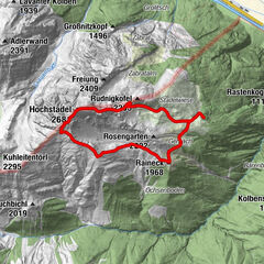
Tour data
8.61km
1,549
- 2,249m
701hm
699hm
04:00h


- Brief description
-
Bergsee, Gipfelerlebnis, bewirtschaftete Almhütte – alle Elemente einer gelungenen Bergtour.
- Difficulty
-
medium
- Rating
-
- Route
-
Seidernitztörl (2,225 m)2.5 kmDachskofel (2,272 m)2.6 kmMokarspitz (2,305 m)3.1 kmAlmgasthof Bergheimat8.1 kmLeppneralm8.5 km
- Best season
-
JanFebMarAprMayJunJulAugSepOctNovDec
- Highest point
- 2,249 m
- Height profile
-


- Author
-
The tour Über die Mokarspitze zur Griebitschalm is used by outdooractive.com provided.
GPS Downloads


General info
Refreshment stop
A lot of view
Other tours in the regions