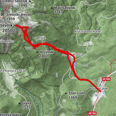
Skitour_Kosiak_18122011

Logo Skitour_Kosiak_18122011
Tour data
5.62km
960 - 1,992m
Distance
1,020hm
Ascent
03:30h
 
Duration
Rating
Technique
Fitness
Landscape
Experience
Starting point

Stouhütte 960m

Route
Johannsenruhe
2.4 km
Matschacher Alm / Mačenska planina
4.4 km
Kosiak (2,024 m)
5.5 km

Highest point
1,992 m

Rest/Retreat

Klagenfurter Hütte


Overall rating

5

0

%

4

0

%

3

0

%

2

0

%

1

0

%

Error
An error has occurred. Please try again.
Thank you for your review

Rating has been deleted

GPS Downloads
  • GPX GPS Exchange Format (XML)
  • KML Google Earth, Google Maps
QR Download Codes for Mobile Phones
Other tours in the regions

Popular tours in the area

Skitour Kleiner Frauenkogel

medium Ski tour
16.6km | 1099hm | 03:55h

Schitour Ogrisalm vom Bodenbauer

medium Ski tour
9.18km | 579hm | 02:30h