- Brief description
-
Beautiful day hike from Stampa via Soglio to Castasegna with several places to stop and one or two cultural highlights.
- Difficulty
-
medium
- Rating
-
- Starting point
-
Stampa
- Route
-
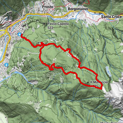
Al CalcettStampa (995 m)0.1 kmLa Stala0.6 kmColtura0.6 kmValär0.6 kmDulezi1.6 kmCaccior (929 m)2.2 kmPromontogno (832 m)3.2 kmSils im Bergell (1,097 m)4.6 kmReformierte Kirche Soglio4.9 kmStüa Granda4.9 kmLò5.0 kmSot Funtana5.1 kmCarnella5.1 kmPregüi5.6 kmCascate del Caroggia6.1 kmStoll (863 m)6.5 kmVazza6.5 kmClüs6.6 kmBrentan7.5 kmChiesa Evangelica Riformata della Santissima Trinità8.1 kmCastasengen (690 m)8.2 kmChiesa riformata di San Giovanni Battista8.2 km
- Best season
-
JanFebMarAprMayJunJulAugSepOctNovDec
- Description
-
From the "Ciäsa Granda" in Stampa, the path leads through Coltura, past Palazzo Castelmur along the narrow road to Caccior. Here you take a path into the forest and after a short while climb steadily up the wide stone steps. At the end of the climb, the forest thins out and offers a fantastic view of Piz Cengalo and the Bondasca valley, before you reach the first houses of Soglio via some pastures.
The path to Castasegna initially follows the main road and branches off after a few bends in the form of a small footpath down to the left. After crossing the road several times, the trail continues on the right at Plazza following the signpost on a gravel road. Through a tunnel under the waterfall and then through the Brentan chestnut groves to the post bus stop at Castasegna.
In Soglio and as well as in Castasegna, the hike can be easily interrupted for a sunny coffee break or lunch... - Directions
-
From the "Ciäsa Granda in Stampa, you walk across the arched bridge over the river Maira. On the other side, follow the village road on the left through Coltura and beyond the village. At the crossroads, follow the road on the left to Caccior (993 m). There we turn onto the footpathto the forest. On a mule track with wide stone steps we finally reach a flat panoramic path that leads over green meadow areas to Soglio.
The path to Castasegna initially follows the main road and branches off after a few bends in the form of a small footpath down to the left. After crossing the road several times, the trail continues on the right at Plazza following the signpost on a gravel road. Through a tunnel under the waterfall and then through the Brentan chestnut groves to the post bus stop at Castasegna. - Highest point
- 1,121 m
- Endpoint
-
Castasegna
- Height profile
-
 © outdooractive.com
 - Equipment
-
Hikingshoes
- Safety instructions
-
In winter and when there is a risk of frost, the path from Caccior to Soglio must not be used!
- Tips
-
Follow the Chestnut Trail in Brentan instead of going straight down to the village
- Directions
- Public transportation
-
Where we are - Bregaglia Engadin Turismo


- Author
-
The tour Stampa - Soglio - Castasegna is used by outdooractive.com provided.


General info
-
Comer See
755
-
Val Bregaglia Engadin
461
-
Soglio
73