- Brief description
-
The violet way crosses the mountainous Julian Alps, in close proximity to, Triglav (2,864 m). The descent from Luknja passes under Triglav's Northern Rock Face.
- Difficulty
-
medium
- Rating
-
- Starting point
-
Hut Tržaška koča on Dolič
- Route
-
Pod Steno (1,888 m)1.3 kmJolanda (1,760 m)2.5 kmPri Bajti3.0 kmAljaževa kapela sv. Cirila in Metoda9.0 kmAljažev dom v Vratih9.0 km
- Best season
-
JanFebMarAprMayJunJulAugSepOctNovDec
- Description
-
The Purple Trail begins at Tržaška koča na Doliču and follows a wide mule track along the one-time border built by the Italian army after the First World War. After a few minutes' walk, there is a junction where the trail branches off to the right on a very rigorous ascent of Triglav (2,864 m). Alternative: If you wish to climb Triglav, turn right at the junction and walk up the mule track. This route is very difficult but well protected with steel cables and pins.
Take the mule track from the junction below Tržaška koča na Doliču. Walk down the relatively level but winding path towards the Zadnjica valley. The path leads past the southern edge of the spacious Zelenica plateau. The trail pasess Luknja pass before descending into Vrata valley, pass the junktion with the trail comming from Triglav, where you will find drinking water (not in the hot months). The trail heads under the famous North Face of Triglav.
- Directions
-
The Purple Trail begins at Tržaška koča na Doliču and follows a wide mule track along the one-time border built by the Italian army after the First World War. The signposts indicate the beginning of the trail and the direction of Luknja and the Zadnjica valley. After a few minutes' walk, there is a junction where the trail branches off to the right on a very rigorous ascent of Triglav (2,864 m).
Alternative: If you wish to climb Triglav, turn right at the junction and walk up the mule track. The track leads to a spacious Karstic meadow. There is a junction at the top where a signpost guides you to the steep and rocky slope leading up to Triglavska škrbina and via the ridge to the peak. Descend on the other side by way of a narrow ridge across Mali Triglav and Triglavski dom na Kredarici (2,515 m), then continue past Dom Valentina Staniča (2,332 m) and Begunjski studenec stream. Go across Prag to the Vrata valley and Aljažev dom v Vratih (1,015 m). This route is very difficult but well protected with steel cables and pins.
Take the mule track from the junction below Tržaška koča na Doliču. Walk down the relatively level but winding path towards the Zadnjica valley. The path leads past the southern edge of the spacious Zelenica plateau. To the right is a view of the tattered northern rock face of Kanjavec. Bare rock is gradually replaced by dwarf pine and larch. The path encircles Skok and leads to the junction at Korita. 1h 15 min. Korita (trough) is a deep incision that descends into the Zadnjica valley on one side, and rises to the Luknja pass (1,758 m) on the other. Because Korita is impassable, the route follows the mule track which runs above it.
The climb up the steep slope should be attempted in stages as it covers an altitude difference of 250 m. The 1h 30 min climb eventually leads to the Luknja pass, from where there is a magnificent view of the Vrata valley below. This grassy pass is a good spot to stop and rest after the climb. Descend Luknja from the other side through a narrow and rocky valley, then across a scree slope lying below the Triglav North Face. The terrain below the scree slope levels out and gradually gives way to growth.
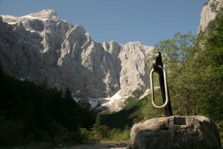
Follow the well-trodden path to the valley and pass the monument on the way to the bed of the Bistrica stream to the junction with the route from Triglav via Prag. The pure drinking water here offers good refreshment but the stream disappears during the hot Summer months. 1h10 min. Walk through the beech wood to the level floor of the Vrata valley and pass the monument to fallen Partisan soldiers, reaching Aljažev dom na Vratih in 20 minutes. The entire route takes 4h 15 minutes. Aljažev dom lies in the upper reaches of the Vrata glacial valley. It was named after Jakob Aljaž, the "Triglav priest", one of the most important figures in the history of mountaineering in Slovenia: He is merited with building the first timber hut here in 1896.
- Highest point
- 2,168 m
- Endpoint
-
Hut Aljažev dom in Vrata
- Height profile
-
 © outdooractive.com
 - Equipment
-
Sturdy boots, sun protection, enough water. Helmet and self protection gear for Triglav.
- Safety instructions
-
The detour on Triglav is quite demanding and steep, only experienced mountaineeres should attempt it. Make sure you have enough time/daylight for detour.
- Tips
-
Carry enough water since in summer months, the springs can be dry. You are in high mountains, so mind the weather.
- Additional information
-
In summer months make reservation for overnight in huts in advance.
- Directions
-
You can reach the hut on Dolič from the trenta valley.
- Public transportation
-
Starting or finishing point is not accesible by public transfer. You can reach Mojstrana with bus, and take 10km walk to the hut Aljažev dom in Vrata valley (basicly stage 2)
- Parking
-
Parking possible in Mojstrana.
- Author
-
The tour Via Alpina Slovenia: Purple Trail: Stage 1 (Dolič-Vrata) is used by outdooractive.com provided.


General info
-
Region Villach - Faaker See - Ossiacher See
2064
-
Goriška
389
-
Trenta
155