

- Brief description
-
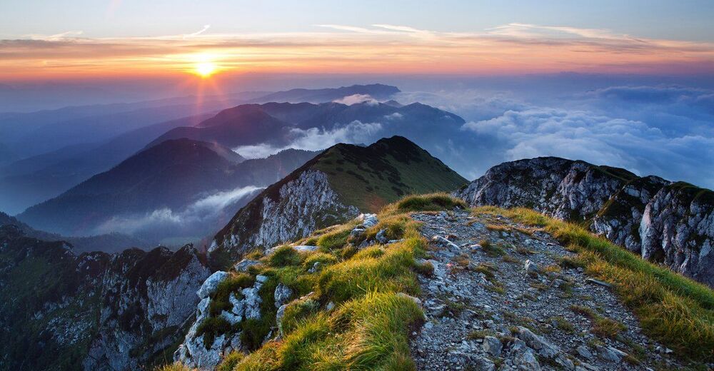
Relatively steep, but technically easy hike to the 1844m high Črna Prst, from where you are rewarded with beautiful views towards the central massif of the Julian Alps.
- Difficulty
-
medium
- Rating
-
- Starting point
-
Intersection just beneath the railway station in Podbrdo (Kacenpoh)
- Route
-
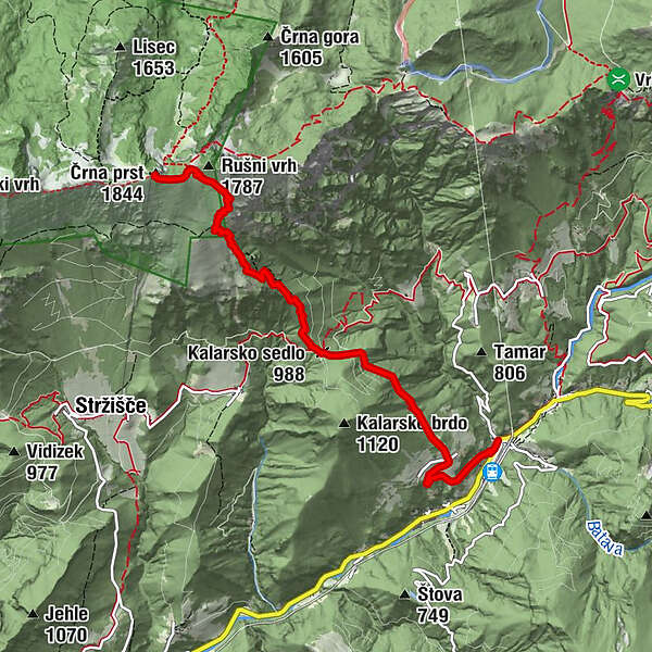
PodberdaTrtnik1.1 kmKalarsko sedlo (988 m)2.7 kmČez Suho (1,760 m)5.4 kmDom Zorka Jelinčiča5.8 kmČrna prst (1,844 m)5.8 km
- Best season
-
JanFebMarAprMayJunJulAugSepOctNovDec
- Description
-
A good three-hour long hike to the 1844m high Črna prst is a bit more demanding, mainly due to the fact that the route is almost constantly ascending. After the initial ascent of the asphalt road into the village of Trtnik, through the steep slope you continue into the forest. After a good hour of steep ascent through the woods you rise up above tree line and will get a first glimpse of wonderful views of the upper Baska grapa and the pre-Alpine hills. On the saddle just beneath the summit, the view opens north towards Bohinj Lake and the mighty Triglav in the background. From the summit on a beautiful day you the panormaic view extends from the Kamnik-Savinja Alps, through the Karavanke and the Julian Alps to the Adriatic Sea. A few meters below the summit there is Zorko Jelincic mountain hut., opened in the summer months.
- Directions
-
We start the ascent in front of the residential blocks at the crossroads under the Podbrdo railway station (Kacenpoh). From there we continue towards the steep surfaced road to the village Trtnik, which is reached after about 20 minutes of walking. In the village, we see the Črna prst markings straight up the stairs of the apartment house, and then onto a grassy slope that climbs steeply between the trees. Higher up the path passes into the forest, and soon we partly join the rocky road that we follow to the right. This leads in places through more steep slopes, which are naturally covered with fallen leafs, which means that additional care is needed there. After crossing a slightly larger gorge, trail leads us to the forest road, after which we climb up to the saddle with a crossroads. Markings point us up to the left on the footpath, which starts a climb all the steep climbs through the forest. The higher path passes a bit, and then brings us to the viewpoint with a bench. Slightly behind the bench, the path splits into two parts (the right is trailing the right way), then again after about 15 minutes, again unite. Just a little over the merger of both paths, we arrive to the next bench, from which we open a nice view towards Kobla and peaks above the Soriška planina. From the hut we continue through the forest for a short time, then the path passes to the more viewable grassy slopes. When we step out of the woods, the path slowly turns slightly towards the right, then turns left and crosses to the saddle Čez Suho where the path from the Bohinj side joins us. We continue to the left and look at Baška grapa, Bohinj and the highest the summits of the Julian Alps, in a few minutes climb to the Dom na Črni prsti, which is located just a few meters below the summit. Zorko Jelinčič's house is on the left and after a short steep slope, we climb a peak in a few steps.
- Highest point
- 1,817 m
- Endpoint
-
Črna prst summit, 1844m.
- Height profile
-
 © outdooractive.com
 - Equipment
-
Good trekking shoes, windstopper, hiking poles are recommended.
- Safety instructions
-
Zorko Jelincic's hut operates during the summer months (food, drinks, overnight stays). At the time the cottage is closed, the a modest bivouac offers shelter.
This is an easy hiking trail. Use of hiking trails is at your own risk!
- Tips
-
During the summer months (June-September), we advise you to start a hike in the early morning hours, since the hardest sections of the route are exposed to the sun.
- Additional information
-
Information and hut reservations:
+386 31 260 400
pdpodbrdo73a@gmail.com
- Directions
-
From Nova Gorica: 103 north to Tolmin, continue along 102 to Bača pri Modreju, turn left to 403 towards Podbrdo.
From Ljubljana: 211 towards Kranj, after Medvode turn to 210 to Škofja Loka, from there 403 towards Podbrdo (via Železniki).
From Bled/Bohinj: From Bled take 209 to Bohinjska Bistrica, continue on 909 and cross Soriška planina to Petrovo Brdo, there join 403 to Podbrdo.
From Bovec: Take 203 to Kobarid, there continue on 102, pass Tolmin to Bača pri Modreju, turn left to 403 towards Podbrdo.
- Public transportation
-
TRAIN: Daily train connection from Ljubljana, Bohinj, Most na Soči or Nova Gorica. Hike starts only 400m from the train station.
Check timetable: http://www.slo-zeleznice.si/en/
BUS: Bus from Tolmin, weekdays only.
Check timetable: https://www.avrigo.si/potniski_prevozi_eng/linijski_promet_eng/vozni_red_eng/
- Parking
-
Free parking available at the train station Podbrdo, only 400m away from the starting point.


-

-
AuthorThe tour Julian Alps: Črna Prst is used by outdooractive.com provided.