Via Alpina Slovenia: Purple Trail: Stage 10 (Zg.Jezersko- EisenkapllerHuete)


- Brief description
- Difficulty
-
difficult
- Rating
-
- Starting point
-
Zgornje Jezersko
- Route
-
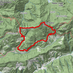
SeelandGostišče ob Planšarskem jezeru2.1 kmSeebergsattel5.0 kmPasterksattel (1,401 m)8.2 kmKepp (1,633 m)9.3 kmTrögern (928 m)13.1 kmSilberbründl18.2 kmEbriach19.9 kmObiralm (1,272 m)23.0 kmEisenkappler Hütte (1,555 m)24.3 km
- Best season
-
JanFebMarAprMayJunJulAugSepOctNovDec
- Description
-
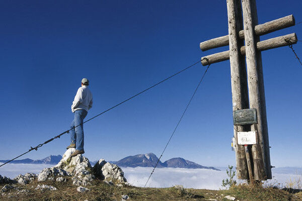
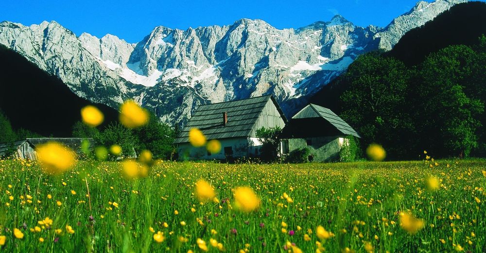
A very beautiful stage with wonderful views of the tallest peaks of the Steiner Alps awaits you, especially if the trail over the Kärntner Storschitz (a very nice vantage point) is taken, which does however require you to be free of vertigo and sure of foot.
Have a comfortable rest in Trögern before continuing through the nature reserve of the Trögerner Klamm gorge. This is a scenic and geological and botanical interesting, about 3 km Long Canyon within the Schlern-dolomite of Koschuta-unit. The nature protected gorge has bizarre rock-formations and is a wild romantic gorge scenery where the Trögern-creek flows through. The hike through the canyon will take about 1,5h.
After the gorge the trail continues upwards to the Eisenkappler hut, which is very popular day's trip for many hikers in the area. The hut is below the summit, you will need aditional half an hour to reach the top.
- Directions
-
This border-crossing stage starts at the direction panels in the centre of the village of Zgornje Jezersko (880 m). Follow the direction of the Slovene balcony trail "No. 1" across the bridge over the Jezernica stream, then turn left immediately on the other side. Follow the stream along a good macadam road to the junction with the tarmac road. Turn right at the junction and walk for a few hundred metres to the tourist buildings near the lake of Planšarsko jezero. 15 minutes. Turn left here and follow the tarmac road, which joins the main road at the church and the Jezerski vrh border crossing. Do not go that way, but rather turn right onto the tree-lined macadam road. To the south, you will notice a beautiful Alpine scene with the Ravenska Kočna valley (cross-country skiing in Winter, hiking trails in the summer) and sheer rock face of the Kamnik Alps, with the peak of Grintovec (2,558 m) towering in the background. Cross the courtyard of the farmstead and walk to the end of the fenced area, then turn left onto the dirt track. Follow the track to the tarmac road until you reach the main road and border crossing after about 100 m. 15 minutes. Cross the road and climb up the steep dirt track. After a few sharp turns, the dirt track leads you to a monument and a bench. Continue walking along the dirt track until you reach the holiday house, then follow the macadam road to the main road. The Jezersko international border crossing at Jezerski vrh (1,218 m) is 1 km down the main road. 40 minutes. There will be direction panels 10 m beyond the border to left.
On reaching the Seebergsattel mountain pass, cross the border into Austria. Follow the signs for Trail 08 along a forest road flanking the Kärntner Storschitz to the Pasterksattel pass at 1,401m. Here, Via Alpina takes a turn to the West to the Kepp, which stands at 1,635m. The trail leads along a downhill track through the woods and across meadowland to the hamlet of Trögern (988m) (approx. 3h from the Seebergsattel pass). Here, the inn invites you for a cosy afternoon tea under the lime tree. From Trögern, a forest road leads further downwards to the Gasthof Franzl inn and into the Trögern Klamm ravine. The path in the ravine is unfortunately covered in asphalt, but even that cannot undermine the beauty of the ravine. The Trögernerbach stream has eaten its way into the precipitous rocks, flooding numerous stone troughs of varying size, in which the water takes on a dark green colour. After approx. 3km, the Trögern stream flows into the Ebriachbach. Keep to the right here, in other words towards the East. After a short while walking along the road, Via Alpina swings off to the left at the Gasthof Schmied inn (Kovac). An extremely steep track leads uphill in the direction of the Eisenkappler Hut.
First, however, you will reach the ancient Meierhof residence in the Obiralm pasture. From there, it is no longer far to the refuge. Crossing the private roadway twice, you will arrive in approx. 30 more minutes in the lovely setting of the Eisekappler Hut at 1,553m. The detour to the summit of the Hochobir, the highest peak in the eastern Karawanken Alps standing at 2,139m, should not be missed. From the refuge, the summit can be reached in approx. 1h 30min. The view is really unique: on one side, the entire Klagenfurt basin with its numerous lakes stretches out before the observer and on the other side, there is an outstanding extensive view on good days – even the Großglockner, the highest mountain in Austria, and the Triglav at whose feet the Purple Trail branches off from the Red Trail of Via Alpina, can be seen. A compass card makes it easier for visitors to pinpoint the famous surrounding peaks.
- Highest point
- 1,620 m
- Endpoint
-
Eisenkappler Hut
- Height profile
-
 © outdooractive.com
 - Equipment
-
Usuall hiking equipment.
- Safety instructions
-
No special safety issues on the trail.
- Tips
-
You can shorten your stage by finding a ride to the top of Jezerski Vrh.
- Additional information
-
Don't forget your passport, since you will cross the border.
- Directions
-
By bus or by car from direction of Kranj
- Public transportation
-
There is a regular bus connection from Kranj to Jezersko.
- Parking
-
Free parking available at Zgornje Jezersko.


- Author
-
The tour Via Alpina Slovenia: Purple Trail: Stage 10 (Zg.Jezersko- EisenkapllerHuete) is used by outdooractive.com provided.