© Intersoc VZW - Frank Inghelbrecht


- Brief description
-
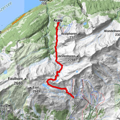
Stechelberg - Schmadrihütte - Stechelberg
- Difficulty
-
difficult
- Rating
-
- Route
-
Rüti0.0 kmStechelberg (867 m)0.0 kmHotel Restaurant Stechelberg0.0 kmRehtschuggen0.5 kmBerggasthof Trachsellauenen2.3 kmSchmadrihütte7.5 kmTalbachfall13.4 kmBerggasthof Trachsellauenen15.3 kmRehtschuggen17.3 kmHotel Restaurant Stechelberg17.7 kmRüti17.7 kmStechelberg (867 m)17.7 km
- Highest point
- 2,247 m
- Endpoint
-
Stechelberg
- Height profile
-
 © outdooractive.com

-

-
AuthorThe tour WEN-DW - Stechelberg - Schmadrihütte - Stechelberg is used by outdooractive.com provided.
GPS Downloads


Other tours in the regions
-
Aletsch Arena
1475
-
Jungfrau Region
1010
-
Mürren - Schilthorn
347