


- Brief description
-
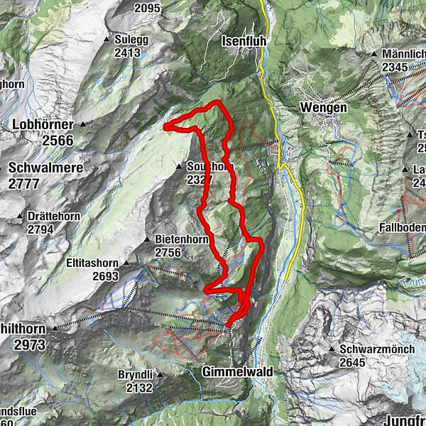
The hike to the Sausläger is an extended hike from the famous Mountain-View Trail. From Sausläger you have further options to hike to the famous Lobhornhütte, Sulwaldhütte or Isenfluh.
- Difficulty
-
medium
- Rating
-
- Starting point
-
Mürren village (1659 m ü. M.)
- Route
-
UnderwaldHinter der EggEggli0.0 kmAuf den Balmen0.1 kmAuf dem Bühl0.1 kmBrunnen0.1 kmGeissdiehleboden0.2 kmBeim Schulhaus0.2 kmMürren (1,650 m)0.2 kmGritt0.2 kmBachstutz0.2 kmAchermannshaus0.3 kmLus0.3 kmMarienkapelle0.3 kmBorthalten0.3 kmAuf dem Bort0.3 kmAuf den Platten0.4 kmPlace Centrale0.4 kmRauft0.5 kmReformierte Kirche Mürren0.5 kmGruebi0.5 kmHöhenmatte0.7 kmResidence Eiger0.9 kmÄgerten1.0 kmAllmihubel2.4 kmFlöschwald8.5 kmGrütschalp (1,481 m)11.3 kmGrütsch11.4 kmBergrestaurant Winteregg13.1 kmWinteregg (1,588 m)13.3 kmÄgertenbachfall15.4 kmÄgerten15.7 kmMürren Bahnhof15.8 kmResidence Eiger15.8 kmRauft16.0 kmHöhenmatte16.0 kmGruebi16.2 kmPlace Centrale16.2 kmAuf den Platten16.3 kmBorthalten16.3 kmLus16.3 kmAuf dem Bort16.3 kmGeissdiehleboden16.3 kmMürren (1,650 m)16.3 kmAchermannshaus16.4 kmGritt16.4 kmBachstutz16.4 kmBeim Schulhaus16.4 kmBrunnen16.5 kmAuf dem Bühl16.5 kmAuf den Balmen16.6 kmEggli16.6 kmHinter der Egg16.7 kmUnderwald16.7 km
- Best season
-
JanFebMarAprMayJunJulAugSepOctNovDec
- Description
-
This hiking tour can be started from Mürren or directly from Allmendhubel. The hike first leads over the "Mountain-View Trail" to Pletschenalp, where no major ascent or descent is possible. Now we continue over the Marchegg down to the Sausläger. The hike can also be extended there accordingly. The way back through the “Spryssenwald” is very pleasant and without major ascents. From the Grütschalp a footpath leads back to Mürren.
- Directions
-
Mürren - Allmendhubel - Pletschenalp - Marchegg - Sausläger - Spryssenwald - Grütschalp - Mürren
- Highest point
- 1,889 m
- Endpoint
-
Mürren village (1650 m ü. M.)
- Height profile
-
 © outdooractive.com
 - Tips
-
Beautiful viewpoint on Marchegg
Possibility to continue hiking to Lobhornhütte, Sulwald or Isenfluh - Additional information
- Directions
-
There are different ways to reach the region by car. The fastest way from Basel and Geneva is via Berne. The fastest route from Zurich is through Lucerne and the Brünig Pass. The pass is open in summer and winter.
From the south, the route goes over the Grimsel or Susten Pass into the region. Both passes are only open in summer. Alternatively, you can take the Simplon Pass and then Lötschberg car transport.
- Public transportation
-
Switzerland, Intercity trains run directly from Basel and Lucerne to the Jungfrau Region. Travellers from Zurich have to change in Berne. The trains run every half hour.
The cable car takes visitors up to the Grütschalp. Continue on from here by train to Mürren with the Lauterbrunnen-Mürren mountain railway (BLM).
Another alternative is the Stechelberg – Gimmelwald – Mürren aerial cableway.
- Parking

- Author
-
The tour Round hike Sausläger (5h) is used by outdooractive.com provided.


General info
-
Aletsch Arena
1485
-
Jungfrau Region
1021
-
Lauterbrunnen
441


