- Brief description
-
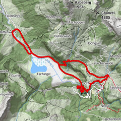
The high-altitude trail between Höchst and Silleren is the most colourful section. A rich alpine flora is described here in this small but fertile area.
- Difficulty
-
easy
- Rating
-
- Route
-
Sillerenbühl (1,975 m)0.0 kmHahnenmoospass (1,950 m)3.2 kmBerghotel Hahnenmoospass3.2 km
- Best season
-
JanFebMarAprMayJunJulAugSepOctNovDec
- Description
-
The flower trail is considered one of the most beautiful themed trails in the entire region. The starting point Sillerenbühl is easily accessible by train from Adelboden. The starting point is also a beautiful vantage point with a view of the famous mountain peaks of the Bernese Oberland. At almost 2000 meters above sea level is started with the goal Hahnenmoospass. The high-altitude hike is a discovery tour that names the extraordinary high alpine flora on countless small boards. On gentle slopes, it leads to the Hahnenmoospass, the border between the two municipalities of Adelboden and Lenk.
- Highest point
- 2,026 m
- Height profile
-
 © outdooractive.com
 - Arrival
-
By car to Adelboden. At the roundabout at the entrance to Adelboden, take the third exit, follow the street for approx. 200 m, then leave the road and go straight ahead to the parking lot to the left in the direction of the Sillerenbühl valley station.
- Public transportation
-
By train to Frutigen and from there by bus to the Adelboden Mineralquelle stop, which is near the Sillerenbühl valley station. With the Silleren cable raillway to Sillerenbühl mountain station.
Return journey: With the Silleren cable raillway, scooter or bus back to the valley station, then again by bus and train.
- Parking
-
All parking spaces are chargeable, CHF 5.- flat rate per day.

- Author
-
The tour Floral Trail (Blumenweg) is used by outdooractive.com provided.


General info
-
Oberwallis
1883
-
Adelboden
986
-
Lenk im Simmental
291