- Brief description
-
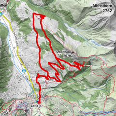
This tour leads to the Elsigen-Metsch ski area.
- Difficulty
-
medium
- Rating
-
- Starting point
-
Adelboden Kirche
- Route
-
Adelboden (1,350 m)Dorfkirche0.0 kmHeilsarmee0.1 kmSchlegeli0.4 kmMoosweid1.6 kmChalleweid2.2 kmUndere Hirzbode3.5 kmGasthaus Elsigbach7.0 kmElsigbach (1,302 m)7.1 kmBerghaus Elsigenalp10.8 kmWildstrubel22.9 kmBodenkapelle23.0 kmBoden23.1 kmOey24.1 kmDorfkirche24.6 kmAdelboden (1,350 m)24.7 km
- Best season
-
JanFebMarAprMayJunJulAugSepOctNovDec
- Description
-
Drive from the village of Adelboden over the Schmittengraben to Margeli and turn right into Elsigbachstrasse. The paved road continues to Elsigbach. At the Elsigen valley station, the road climbs up the valley run to Elsigenalp. When you arrive at Elsigenalp, the breathtaking mountain panorama stretches out in front of you. We continue at the Brandsee in the direction of Höchst. The descent meanders through forests and already offers you a view of Adelboden. When you arrive at Alp Höchst, drive up the natural road to Bonderalp. From the Bonderalp the descent follows via Ahorni to Boden via the Fuhre back to Adelboden.
- Directions
-
Adelboden - Margeli - Elsigbach - Elsigenalp - Höchst - Bunderalp - Bonderlen - Walezube - Boden - Fuhre - Adelboden
- Highest point
- 1,809 m
- Endpoint
-
Adelboden Kirche
- Height profile
-
 © outdooractive.com
 - Directions
-
By car to Adelboden. At the roundabout at the entrance to Adelboden, take the second exit towards Adelboden Dorf. The parking garage is located in the center of the village.
- Public transportation
- Parking
-

-
AuthorThe tour E-Bike Elsigen-Metsch is used by outdooractive.com provided.


General info
-
Oberwallis
120
-
Adelboden
84
-
Frutigen
24