


- Brief description
-
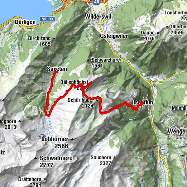
Mountain hiking trail from Nessleren/Underberg. Very rewarding ascent through the Saxettal valley floor across alpine meadows resplendent with flowers to the flank of the Sulegg and over the saddle between Bällenalp and Sylertal to one of the most beautiful vantage points anywhere in the Jungfrau Region, the Bällehöchst. The descent is no less impressive, past the dreamy Sulsseewli with its magnificent reflection. This varied tour concludes with a forest hike down to Isenfluh, situated on a panoramic terrace. The first 1 km of the trail is on a paved surface.
- Difficulty
-
medium
- Rating
-
- Route
-
Saxeten (1,101 m)0.0 kmSkpintli0.6 kmInnerfeld0.6 kmBällenhöchst (2,095 m)7.7 kmBergherrenhaus12.4 kmAuf dem Rauft14.1 kmGärten14.4 kmBeim Brunnen14.4 kmIsenfluh14.4 kmBeim Schulhaus14.4 kmGassen14.4 kmBoden14.4 kmRestaurant Waldrand14.5 kmAuf der Matte14.5 km
- Best season
-
JanFebMarAprMayJunJulAugSepOctNovDec
- Description
-
The Alpine village of Saxeten, with less than 100 inhabitants, is well known as the starting point for several unique peak treks. The nearby hiking destinations of Bällehöchst and Morgenberghorn offer incomparable panoramic views.
From the minibus station, take the narrow road into the valley towards Innerfeld. The paving comes to an end at Rengggraben, where the narrow alpine road continues and begins to climb more steeply. When it turns a few hundred metres out of the valley, it reveals a view of the waterfalls of the Wyss and Saxet streams. The road’s large horseshoe bend follows the route of the old alpine trail, with the gradient easing off slightly only just before reaching the Nessleren chalet/Underberg. The powerful massif of the Schwalmere dominates the cirque.
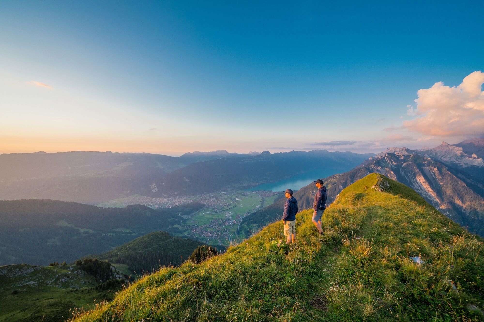
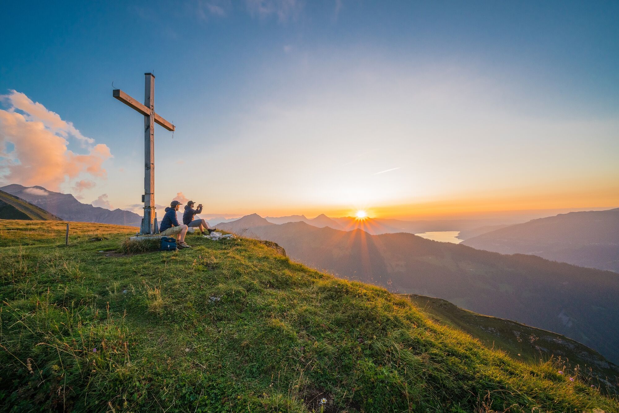
The road descends a little to the Saxetbach stream, narrows to an alpine trail, then becomes a footpath as it again ascends steeply. Hiking through areas of forest and across flower-filled meadows, you approach Hinder Bällen above the treeline (to Saxetwald-Saxeten 2hrs, to Saxetwald-Wilderswil 2hrs 40 mins). Your strenuous ascent is rewarded with a magnificent view of the Leissig and Därlig ridges curving down to the Aabeberg from the Morgenberghorn. In the valley below, the houses of Saxeten nestle close together. From here, enjoy the first view of the Bällehöchst. Now head for the Usser Bällen alpine hut, some 100 m higher, and climb up to the saddle between Sulegg and Bällehöchst (point 1998), where the views becoming surprisingly different: An extensive scree slope stretches from the Sulegg down to Alp Sylere and numerous gullies have been etched into the slate rubble. You can even hear the water gurgling and the stones rolling when it’s very quiet. The Bällehöchst observation platform is still a good quarter of an hour away. There are few places where it is possible to experience the diversity of the Alpine foothills and the enormous differences in altitude more impressively than here. There are views of the Niederhorn, Hohgant, Schrattenflue and Brienzergrat, while down in the valley, Lake Brienz and the eastern part of Lake Thun can be seen. To the south, the Jungfrau and the mountains at the rear of the Lauterbrunnen Valley sparkle.
To descend, follow the path back to point 1998 and then cross the aforementioned Tschingel scree slope. Caution is advised when crossing the final ridges. Passing the Sulsseewli, with its reflections of the Eiger, Mönch and Jungfrau, you reach the Sulshütten and 10 mins later the huts in the Chüebodmi (to Sousläger-Grütschalp 1hrs 20 mins). The good forest trail descends very steeply as it passes Sulwald en route to Isenfluh.
Descending by cable car from Sulwald to Isenfluh saves three quarters of an hour of this steep descent.
- Highest point
- 2,093 m
- Endpoint
-
Isenfluh
- Height profile
-
 © outdooractive.com
 - Equipment
-
We recommend the following equipment: Sturdy hiking shoes, medium-sized backpack with hip belt, sun protection, rainwear, hiking sticks, first aid kit, picnic, water, mobile phone.
- Safety instructions
-
This hike follows partially or fully signposted mountain trails
- Public transportation
-
Getting there: By train to Interlaken Ost. Then onward by train to Wilderswil. From there by bus to Saxeten, Schulhaus or Saxeten, Alpenrose.
Return journey: From Isenfluh by bus to Lauterbrunnen. From there by train to Interlaken Ost

-

-
AuthorThe tour To the Bällehöchst viewpoint is used by outdooractive.com provided.


General info
-
Oberwallis
1872
-
Interlaken
1099
-
Wilderswil - Saxeten
497


