- Brief description
-
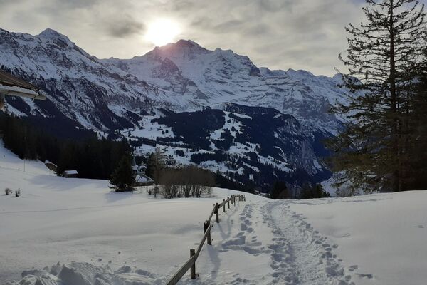
Sit back and relax on the terrace of the Sulwald-Stübli and let your gaze wander over the Eiger, Mönch and Jungfrau as well as the Upper Lauterbrunnen Valley.
- Difficulty
-
medium
- Rating
-
- Starting point
-
Sulwald
- Route
-
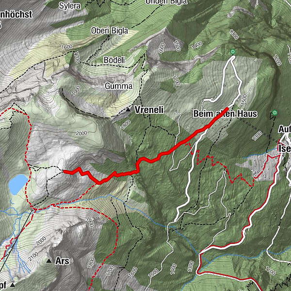
Sulwald0.0 kmSulwald-Stübli (1,520 m)0.0 kmBeim alten Haus0.1 kmHägelisteini0.2 kmSuls-Lobhornhütte (1,955 m)1.9 kmBergherrenhaus3.5 kmHägelisteini3.7 kmBeim alten Haus3.8 kmSulwald-Stübli (1,520 m)3.8 kmSulwald3.9 km
- Best season
-
AugSepOctNovDecJanFebMarAprMayJunJul
- Description
-
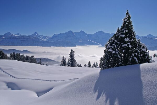
The cable car ride from Isenfluh up to Sulwald takes about 10 minutes. The trail begins right behind the Sulwald-Stübli. Following the «Sulwald Rundweg» sign, the trail at first follows a wide road until it branches off to the right and begins the ascent. After an initial leisurely ascent, the Sulwald forest loop splits off from the Lobhorn Trail, which now continues straight on. Below the Chüematta cliffs of the Schärihubel, the trail goes through a hollow to the east that winds uphill to the Lobhorn hut (1'954 m). After an approximately 2-km-long marked ascent to the Lobhorn hut, a magnificent view of the Jungfrau Region opens up over the Lauterbrunnen Valley in the canton of Berne.
The Lobhornhütte is only guarded from 6 - 16 February 2020 on Saturday and Sunday.
- Directions
-
From Isenfluh with the cable car to Sulwald
Sulwald - Stutz - Gruebi - Orthalti - Lobhorn hut - Highest point
- 1,927 m
- Endpoint
-
Sulwald
- Height profile
-
 © outdooractive.com
 - Equipment
-
Snowshoes
Telescopic poles
Maps
Sun cream & lip protection
Snacks & drinks
If available: altimeter, compass - Safety instructions
-
The Lobhorn Trail should only be done in good snow conditions or with sufficient knowledge.
Further important tips:
Plan enough time, take regular breaks Do not take unnecessary risks and always monitor the weather Always stay on the signposted route, avoid shortcuts Do not disturb wild animals and avoid them as far as possible If possible leave dogs at home or keep them on a leash Take only memories and leave only your trace - Tips
-
From Sulwald there is also a toboggan run down to Isenfluh. Sledges can be rented at the valley station. This allows you to combine a snowshoe tour with a fun descent.
- Additional information
- Directions
-
By car from Basel/Zurich/Geneva via Bern or Lucerne/Brünigpass. This is open summer and winter. From the south, the journey leads via the Grimsel or Susten Pass (only in summer) or Simplon Pass and then the Lötschberg car transport into the region.
Lauterbrunnen
From Interlaken and Wilderswil follow the main road to Lauterbrunnen.Google route planner
Isenfluh
From Interlaken and Wilderswil follow the main road to Lauterbrunnen, about 2 km after Zweilütschinen turn right at the signpost and drive along a winding road to Isenfluh. - Public transportation
-
Thanks to its central location in Europe, Switzerland is served by international trains from over 12 countries. Within Switzerland, Intercity trains run directly from Basel and Lucerne to the Jungfrau Region. Travellers from Zurich have to change in Berne. The trains run every half hour.
The post bus takes guests from Lauterbrunnen train station to Isenfluh in about 15 minutes. - Parking
-
Lauterbrunnen
Lauterbrunnen multi-storey car park or the uncovered car park at the Schilthorn cable car in Stechelberg. The Lauterbrunnen multi-storey car park can be reserved online.Isenfluh
It has a public parking lot with parking meter and a private parking lot near the cable car. In the case of private parking, the parking fee must be easily deposited in the owner's mailbox. If both places are occupied, there is another parking place on the other side of the village.

- Author
-
The tour Lobhorn Trail is used by outdooractive.com provided.


General info
-
Aletsch Arena
143
-
Interlaken
81
-
Lauterbrunnen
22