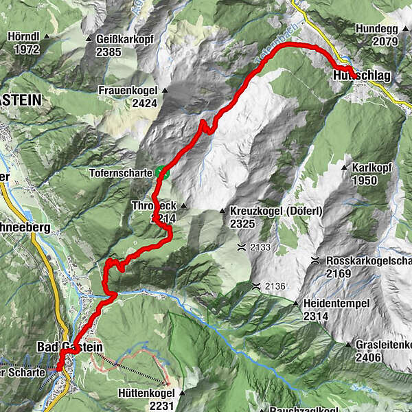
Salzburger Almenweg - Stage 10: Bad Gastein - Hüttschlag


- Brief description
-
Over the highest grass mountain in Europe into the "Valley of the Alpine Pastures"
- Difficulty
-
medium
- Rating
-
- Starting point
-
Bad Gastein (1,090 m) Stubnerkogelbahn valley station
- Route
-
Pyrkershöhe0.3 kmBad Gastein0.9 kmWasserfall0.9 kmGasteiner Wasserfall1.0 kmPreimskirche1.2 kmBadberg1.9 kmBlick nach Bad Hofgastein2.2 kmPoserhöhe5.5 kmOberharbachalm11.6 kmSchappachkapelle16.8 kmHüttschlag16.9 km
- Best season
-
JanFebMarAprMayJunJulAugSepOctNovDec
- Description
-
Are you ready to leave the Gastein Valley after almost a week? Then, we head into the Grossarl Valley on the flanks of the Gamskarkogel, which is visible from afar. Already in imperial times this area was a much sought-after hunting ground and so Archduke Johann had the Gamskarkogelhütte built at the beginning of the 19th century. A detour to the impressive green-glowing Grasberg is thoroughly recommended – whether for a short break or even for an additional overnight stay. The Salzburger Almenweg here does not lead over the summit, but instead to the Tofern Scharte (2,091 metres) 400 metres lower down in the Grossarl Valley, which is also called the "Valley of the Alpine Pastures" due to its abundance of alpine pastures. The mountaineering village of Hüttschlag, like Bad Gastein, is one of the National Park resorts and inspires with its impressive natural scenery. The day will be long, with a challenge for your stamina and legs, but you will also be rewarded for it.
Alpine Trail Peak Tour
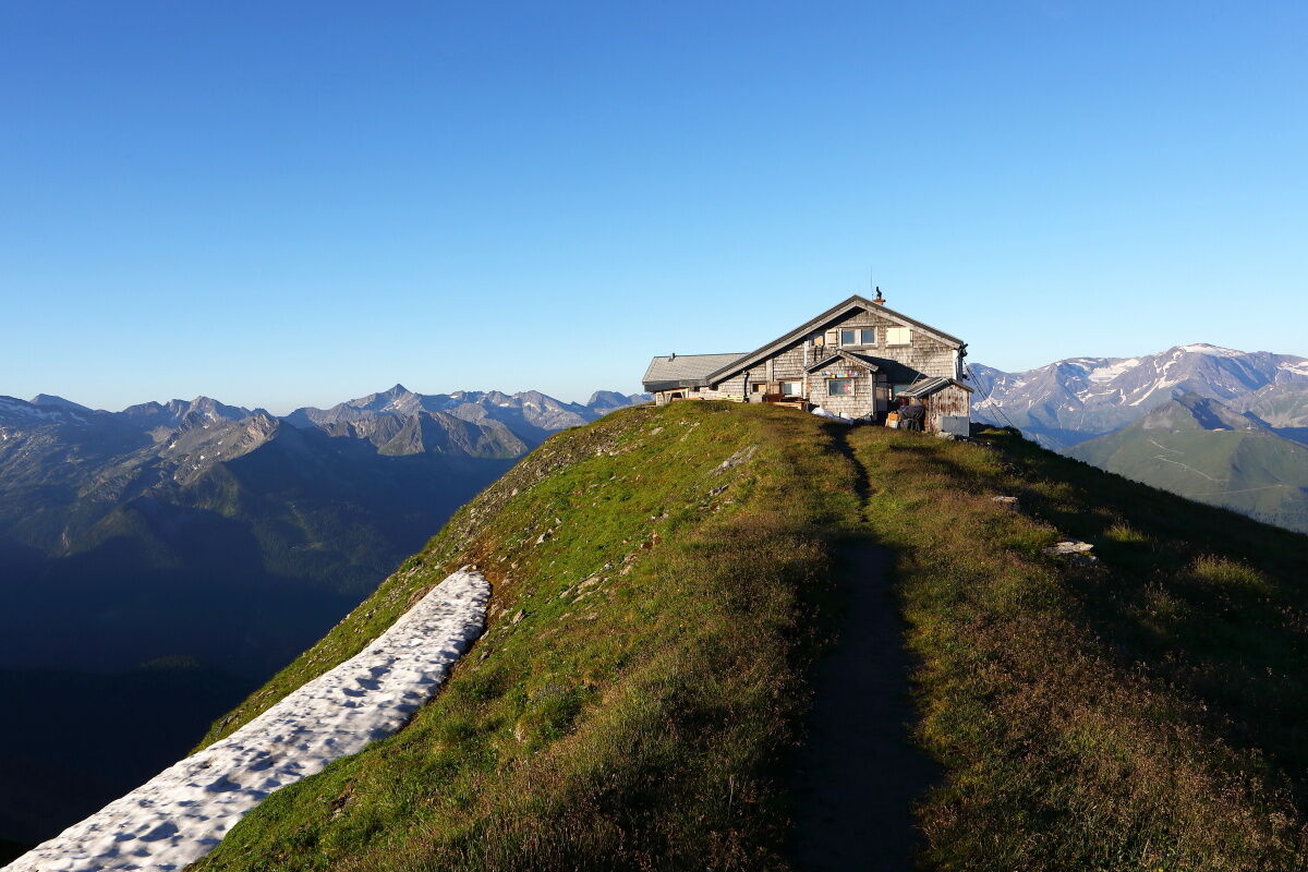
For those who don't want to cover today's stage in a single day or simply cannot yet say goodbye to the Gastein Valley, you have the opportunity to spend the night on the Gamskarkogel. From the Tofern Scharte, instead of descending towards Hüttschlag, you head up to the summit where the ascent takes approx. 1 hour from the Scharte. The hut was built in 1828 on behalf of Archduke Johann, who was often a guest here with his hunting parties. It is one of the oldest mountain accommodations in the entire Alps and is located directly on the 2,467 metre high summit of Europe's highest Grass Mountain. It can accommodate up to 20 people, and an overnight stay up there is certainly one of the most beautiful mountain experiences the Eastern Alps has to offer.
Along the trail
The Tofernalm area in the Grossarl Valley is known for its rich occurrence of yellow and spotted gentian (popularly known as "gentian-root"). Its roots are appreciated for their special healing effect on stomach and intestinal diseases. However, the flowers may not be picked as they are strictly protected. According to a legend, the "Roots Troll of Tofern" lived in this area a long time ago. This little troll was able to make himself invisible, but his nose which was a gentian root, always remained visible. Even today, the “Roots Troll” is said to care for the gentian roots. See if you can spot it or a gentian!
Alpine Trail Refreshment
The Harbachalm is an old miner's hut from the 17th century. In earlier times, the entire Tofern and Reitalm areas were copper mining areas. In addition to specialities such as cheese, butter, bread, bacon and sausage, you should definitely try the apple bread, which is a mixture of scrambled cake and fruit bread.
- Directions
-
The starting point of stage 10 is the valley station of the Stubnerkogelbahn, from where the Almenweg leads through the historic centre of Bad Gastein: on the right past the ticket offices, a passage leads to a glass crossing over the main road through Bad Gastein. On the other side, turn left down to the main road and in front of the Shell petrol station, diagonally right into Grillparzerstraße. In front of the Salzburger Hof, turn left down onto the path and walk past the hotel to the left as well as the famous "Silverbullet" bar. Opposite the Hotel Eden Rock, take a sharp right onto a path that leads down to the historic centre of Bad Gastein. The congress square is crossed as well as the spectacular waterfall by means of a bridge - then keep slightly left to the Preimskirche.
Here, diagonally to the right, the Kaiser Wilhelm Promenade begins. This wonderful walking path leads at a more or less constant altitude, first through the historic Bad Gastein and later through forests towards the Kötschach valley. At a junction, a footpath leads down to the left in the direction of "Poserhöhe" (path no. 514). Cross the stream and follow the path briefly to the left up to a small asphalt road. Now turn left briefly until a meadow path branches off to the right in the direction of "Poserhöhe" (path no. 514). After a house, the path becomes a road, before a short time later a hiking trail branches off to the right (Ww. "Poserhöhe" No. 514). Soon you come to a cart path, which you hike very steeply uphill in serpentines. After quite a while, the hiking trail that branches off to the left should not be missed (if you are standing at a hut, you are wrong). This hiking trail no. 514 leads – crossing a cart path a few times and still quite steep – in serpentines to the Alpenhaus Poserhöhe. This managed alpine hut is located like an eagle's nest above Bad Gastein and is a welcome place to stop for refreshments before the last ascent - perhaps with a delicious Kaiserschmarrn?
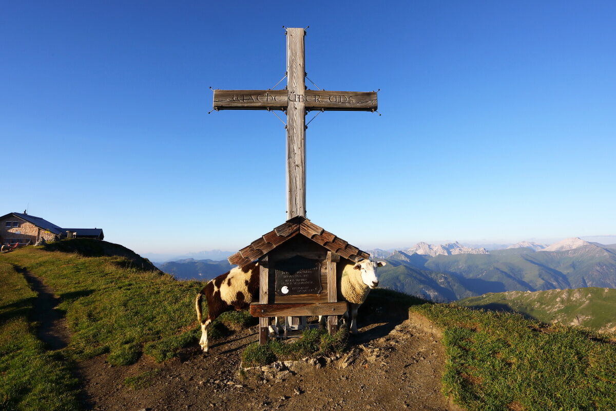
Now directly through the garden of the Alpenhaus and on the other side along the hiking trail, which leads straight up over alpine pastures towards "Gamskarkogel" (path no. 514). This path initially leads straight uphill and later in a long uphill left traverse over sometimes quite steep slopes to below the Tofernscharte. On this rather long ascent, you can see the height gradations of the vegetation wonderfully: From the dense forest you hike over the forest tundra up to the open pastures. One last ascent over alpine pastures and you are on the Tofernscharte. It is located at 2,091 metres above sea level and can be reached in about 2.5 hours from the Poserhöhe.
Once you have arrived at the Tofernscharte, you have the opportunity to climb up to the Gamskarkogel (Ww no. 43/502a, one hour's walk there and back).
From now on, it's all downhill. A meadow trail (Ww. "Hüttschlag-Ortszentrum" no. 43/502a) over beautiful alpine pastures and forest terrain takes the hiker past the unmanaged Tofernalm and once crossing an alpine road down to the managed Harbachalm (1,612 m), the last refreshment stop on this stage.
Immediately after the alpine hut, the next hairpin bend is shortened on a footpath, the alpine road is crossed and a hiking trail is hiked down the valley to the left of the stream until the alpine road is reached again. This is now followed for quite a while slightly downhill out of the valley (Ww. "Hüttschlag-Ortszentrum" No. 42/502a). At a point where a forest road joins it on the left, a hiking trail leads diagonally to the left downhill (Ww. "Hüttschlag-Ortszentrum" No. 43/502a), which leads parallel below the alpine road out of the valley. At a fork in the road, choose the path leading straight ahead – the path widens at some point to a wide meadow path, which is always followed downhill in the same direction until you reach an asphalt road. A shortcut through the forest brings the hiker back to the asphalt road and on to a left-hand bend. Here you leave the asphalt road again and hike down the forest path (Ww. "Hüttschlag-Ortszentrum" No. 43a). After a while, the lower of the two meadow paths leading downhill is chosen, which leads to the first houses of Hüttschlag. Here you can enjoy a unique view of the picturesque mountaineering village® of Hüttschlag, the destination of your tour. Take the gravel path briefly down to an asphalt road and turn right to the centre of Hüttschlag, today's stage destination.
Variant with stage start at your selected accommodation in Bad Gastein:
If you do not want to walk from your accommodation to the Kötschach Valley, the public bus line 555 will take you there comfortably. You can get on the bus in Bad Gastein at Mozartplatz, the train station, Gemeindesiedlung and Graukogellift. From the “Grüner Baum”/Kötschachtal bus stop it goes up to the Poserhöhe.
Refreshment and accommodation options
Poserhöhe (1,502 m), (after approx. 2 hours) mid-April – early November / T. +43 664 4533503 / refresh. / accomm.
Harbachalm (1,612 m), (after approx. 5 hours) mid-July to the end of August, T. +43 664 7867535, Alpine summer hut / refresh.
Numerous places to stop for refreshments an overnight stays in Hüttschlag, www.grossarltal.info refresh. / accomm.
Accomodation Partner Salzburger Almenweg Information and Booking Centre powered by Trail Angels: Haus Hoamatl, more information: http://www.haus-hoamatl.at/, T. +43 664 3917563
Hotel Almrösl, more information: https://www.almroesl.at/, T. +43 6417 601
- Highest point
- 2,078 m
- Endpoint
-
Hüttschlag Town Centre (1,030 m)
- Height profile
-

- Safety instructions
- Tips
-
At the transition from the Tofernalm into the forest stands a small chapel, which was built by a hunter from Hüttschlag in gratitude for the recovery of his wife after a serious illness. It is a place of tranquillity and is intended to encourage hikers to give thanks.
- Additional information
- Arrival
-
You go to Bad Gastein and further to Kötschachtal
- Public transportation
- Parking
-
In Bad Gastein, cars can be parked in the centrally located parking garage or at the Stubnerkogel valley station.


- Author
-
Salzburger AlmenwegThe tour Salzburger Almenweg - Stage 10: Bad Gastein - Hüttschlag is used by outdooractive.com provided.