- Brief description
-
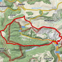
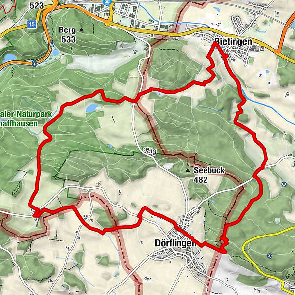
Circular hike with starting point at Bietingen Castle (DE) across German and Swiss territory.
- Difficulty
-
medium
- Rating
-
- Starting point
-
Bietingen Castle
- Route
-
LindeBietingenDörflingen (451 m)5.6 kmGennersbrunn8.9 kmGennersbrunnerhof8.9 kmBietingen15.5 kmLinde15.6 km
- Best season
-
JanFebMarAprMayJunJulAugSepOctNovDec
- Description
-
This varied circular hike, starting and finishing at Bietingen Castle (Germany), takes you through German and Swiss territory, mainly through quiet wooded areas and along the edges of the surrounding forest.
The Gennersbrunnerhof inn (Schaffhausen, Switzerland), which is located directly on the route, offers refreshments along the way. You will reach the inn after about 9 kilometres (please note: Tuesdays and Wednesdays are closed).
- Directions
-
Bietingen - Dörflingen (CH) - Gennersbrunnhof - Bietingen
Difficulty level: 1 (relatively flat, no great differences in altitude)Beauty: 4The starting point of the hike is the castle in Bietingen. From there, we cross over to the other side of the Biber and walk downstream along the Biber. Further ahead, the path leads through a small wood. Where the forest ends on the right, we walk up the path to the right (partly in serpentines). At the top, we keep left and continue along the edge of the forest until we see the Randegg Jewish cemetery to our right at the end of the forest. We then continue along the path, which is tarmac from here. Approx. 200 metres before we reach the Bietingen-Dörflingen country road, we turn right at a crossroads and then reach the country road further up. We continue up this road and at the high point turn left onto a forest path and then immediately take the right-hand path down into the forest. We go straight ahead at the hunter's stand at the bottom, then climb slightly again through three bends and continue straight ahead up the path. We stay on this path until we see boundary stone no. 965 to the right of the path. From here, we walk along a narrow hiking trail along the border and at the end of the forest we come to a path leading along the edge of the forest, which we follow to the right until we reach the first bend. There we take an earth path to the left for about 100 metres down to the vineyards and then keep right again, always following the yellow "Gennersbrunn" hiking sign. We walk past a large half-timbered house, cross the main road and keep right at the wooden fence and then left again after 60 metres. Continue straight ahead along this path until our yellow hiking sign points us to the left (past a small pine grove). We come to a country road, turn left briefly and then take the path on the right again. We continue along the bushes and reach the edge of the forest further on, which we follow until our yellow hiking sign points us to the left, down onto a path that goes up to the right along the ditch. We stay on this path, cross a concrete road at the top and turn left at the end of the path up to the Gennersbrunnhof, where we have a very nice place to stop for refreshments (closed on Tuesdays and Wednesdays). After the refreshment stop, we walk downhill very briefly on the country road towards Dörflingen and then turn left. We follow this path up to the forest and walk along the edge of the forest for approx. 200 metres. At the high point in the corner of the forest, we cross two gravelled forest roads and continue in a straight line downhill, turning right at the bottom along the edge of the forest until we reach the corner of the forest. Now turn left along the edge of the forest and keep right towards Thayngen (opposite a barbecue cellar). This path climbs again further back (a beautiful biotope at the bottom right), then continues along the edge of the forest for about 400 metres and very shortly after the forest begins again on the right of the path, we take the path sharply to the right, circle the small wooded hill and keep right again at the end of the forest. After passing the gas station, we come to the country road, go up it briefly to the left and then turn right again onto the path, which leads us through the forest in a roughly straight line down into the fields. There it leads us to the left over to the edge of the forest opposite, which we follow to the right until we take the path to the right at the end of the forest and cross a small tarmac road. Where the tarmac path then turns right, we continue along the path to the left and, enjoying the view, circle the hill and come to a road at the very front, which we follow to the right down to the main road in Bietingen. On the main road in the village, we keep right, cross the Biber and walk past the fire station back to our starting point.
- Highest point
- 524 m
- Endpoint
-
Bietingen Castle
- Height profile
-
 © outdooractive.com
 - Equipment
-
Good shoes, drinks and snacks for in between.
- Tips
-
Restaurant zum Gennersbrunnerhof, Gennersbrunn Schaffhausen
- Additional information
- Directions
- Public transportation
- Parking
-
Parking spaces are available at the sports field.
- Author
-
The tour Cross-border circular walk Dörflingen is used by outdooractive.com provided.


General info
-
SchaffhauserLand
1027
-
Reiat
474
-
Dörflingen
165